

|
|
|
|
|
|||||||
| Home | Forums | Gallery | Webcams | Blogs | YouTube Channel | Classifieds | Register | FAQ | Members List | Donate | Today's Posts | Search |
 |
|
|
Thread Tools | Display Modes |
 09-25-2016, 10:13 AM
|
#1 |
|
Member
Join Date: Apr 2004
Posts: 49
Thanks: 110
Thanked 10 Times in 6 Posts
|
It seems to me, without specific calculation, that our lake level may be at the lowest I have seen in my fifteen years of lake life. Am I unnecessarily alarmed? Mother Nature is always in control!
|

|
|
09-25-2016, 10:32 AM
|
#2 | |
|
Senior Member
Join Date: May 2005
Posts: 504
Thanks: 5
Thanked 173 Times in 90 Posts
|
Quote:
http://www.bizer.com/bztnews.htm |
|
|
|
| The Following User Says Thank You to rsmlp For This Useful Post: | ||
we're golden (09-13-2019) | ||
|
09-25-2016, 01:58 PM
|
#3 |
|
Senior Member

Join Date: Jul 2002
Location: Central MA
Posts: 2,358
Thanks: 18
Thanked 577 Times in 183 Posts
|
It looks like the outflow was increased this weekend and we lost almost 2 more inches.
We had to pull our jetskiis this weekend and may have to close the camp.
__________________
Island Girl ....... Make Lemonade |
|
|
| The Following User Says Thank You to Island Girl For This Useful Post: | ||
fanfig77200 (09-25-2016) | ||
|
09-25-2016, 04:37 PM
|
#4 |
|
Senior Member
Join Date: Jan 2005
Posts: 130
Thanks: 70
Thanked 33 Times in 25 Posts
|
The Lake water level is down 20.16 inches as of 6 AM this morning, and the outflow was at 293 cfs.
The lack of snow last winter, and rain this spring and summer, placed us in a long term drought situation. Hopefully, this pattern will break in time for winter sports. |
|
|
|
09-25-2016, 09:31 PM
|
#5 |
|
Senior Member
Join Date: May 2016
Location: Alton Bay
Posts: 198
Thanks: 4
Thanked 66 Times in 43 Posts
|
Anyone remember the summer that the level of the lake was so high it was no wake for the season?!
|
|
|
| The Following 3 Users Say Thank You to JADAQ For This Useful Post: | ||
| Sponsored Links |
|
|
|
09-25-2016, 09:57 PM
|
#6 |
|
Senior Member
Join Date: Mar 2006
Location: Merrimack and Welch Island
Posts: 4,596
Thanks: 1,418
Thanked 1,705 Times in 1,109 Posts
|
I have memories of high and low water over the last 6+ decades. I have no knowledge of anytime there was a speed limit "for the season". Once a water + in July. That's it. Several times early in "the season." Low water now. High water is off topic.
|
|
|
|
09-26-2016, 06:44 AM
|
#7 | |
|
Senior Member

Join Date: Nov 2003
Location: Central NH
Posts: 5,253
Blog Entries: 1
Thanks: 1,455
Thanked 1,357 Times in 476 Posts
|
Quote:
Why in the world would they increase the outflow?!!! |
|
|
|
|
09-26-2016, 06:56 AM
|
#8 | |
|
Senior Member
Join Date: Feb 2005
Location: Gilford, NH and Florida
Posts: 3,159
Thanks: 749
Thanked 2,277 Times in 986 Posts
|
Quote:
The lake level was about 18 inches over full lake in July 1998 and it was no wake for Fourth of July week, but then it returned to normal for the remainder of the season. |
|
|
|
|
09-26-2016, 07:02 AM
|
#9 | |
|
Senior Member
Join Date: Mar 2008
Location: Welch Island and The Taylor Community
Posts: 3,386
Thanks: 1,260
Thanked 2,148 Times in 983 Posts
|
Quote:
http://www4.des.state.nh.us/Rti_home...E=Lakeport+Dam |
|
|
|
| The Following User Says Thank You to Slickcraft For This Useful Post: | ||
Rattlesnake Gal (09-26-2016) | ||
|
09-26-2016, 07:48 AM
|
#10 |
|
Senior Member

Join Date: Oct 2004
Location: Laconia NH
Posts: 5,667
Thanks: 3,281
Thanked 1,132 Times in 814 Posts
|
I remember the lake level being very low in midseason. Our dock was dry and we had to beach the boat. The boat had to be moored. Something about the dam was rebuilt or under repair?
__________________
Someday may never be an actual day. |
|
|
|
09-26-2016, 08:13 AM
|
#11 | |
|
Senior Member

Join Date: Mar 2003
Location: Merrymeeting Lake, New Durham
Posts: 2,228
Thanks: 304
Thanked 799 Times in 368 Posts
|
Quote:
|
|
|
|
| The Following User Says Thank You to Merrymeeting For This Useful Post: | ||
WakeboardMom (09-26-2016) | ||
|
09-26-2016, 08:23 AM
|
#12 |
|
Senior Member

Join Date: Sep 2016
Location: Meredith, NH
Posts: 67
Thanks: 12
Thanked 8 Times in 4 Posts
|
I agree its low. I think any major difference in our beloved lake is a cause for concern for most of us here. I just came back from a walk down at the Town Docks and the water is VERY low under the walking bridge. The rocks that are generally submerged with the exception of only a few inches and you can see the water stains at least a foot above where the water is now. We have been in drought, though, so it's not like the lake is hemorrhaging water into some unknown abyss. I'm hoping for a good ice fishing season this year!

|
|
|
|
09-26-2016, 08:56 AM
|
#13 | |
|
Senior Member
Join Date: Nov 2003
Location: Central NH
Posts: 5,253
Blog Entries: 1
Thanks: 1,455
Thanked 1,357 Times in 476 Posts
|
Quote:
|
|
|
|
|
09-26-2016, 09:01 AM
|
#14 |
|
Senior Member
Join Date: Feb 2003
Location: Moultonboro, NH
Posts: 1,692
Blog Entries: 1
Thanks: 356
Thanked 646 Times in 294 Posts
|
Hurricane season isn't officially over till November. One of the forecast models have a storm (currently called 97L) headed our way a week from Friday (October 7'th). All models are wrong, but the potential for an event to refill our pool is not out of the question.
__________________
-lg |
|
|
|
09-26-2016, 10:18 AM
|
#15 | |
|
Senior Member
Join Date: May 2005
Posts: 504
Thanks: 5
Thanked 173 Times in 90 Posts
|
Quote:
|
|
|
|
|
09-26-2016, 10:26 AM
|
#16 |
|
Senior Member
Join Date: Feb 2014
Posts: 273
Thanks: 119
Thanked 62 Times in 40 Posts
|
Attached is a link to the State monitoring station next to the Bridge over Winnisquam. The description at the bottom explains why the flow is maintained at the level it is.
http://www4.des.state.nh.us/rti_home...innisquam+Lake what I'm about to say it TOTAL speculation on my part: up until Labor day Winnisquam had stayed about its "mean level", I believe this was to maintain the flow through the Hydro dam, but since then the lake level has been dropping and that may be to help the Big lake. So Winnipesaukee should rise when (if) they do the draw down after Columbus day. The big question is what happens after that if we do not get significant rain. |
|
|
| The Following User Says Thank You to Dad sold the C * C For This Useful Post: | ||
Pineedles (09-26-2016) | ||
|
09-26-2016, 11:36 AM
|
#17 |
|
Senior Member

Join Date: May 2006
Location: Texas, Lake Ray Hubbard and NH, Long Island Winnipesaukee
Posts: 2,970
Thanks: 1,064
Thanked 912 Times in 539 Posts
|
Have faith in Mother Nature. Sure she is showing us who is in charge... But even in 2001 when the lake went low, it filled up in the spring..... We may be in for a snowy winter and mother nature is just helping us prepare.....
__________________
Life is about how much time you can spend relaxing... I do it on an island that isn't really an island..... |
|
|
| The Following User Says Thank You to LIforrelaxin For This Useful Post: | ||
trfour (09-26-2016) | ||
|
09-26-2016, 01:23 PM
|
#18 | |
|
Senior Member
Join Date: Feb 2012
Location: Tuftonboro
Posts: 1,275
Thanks: 196
Thanked 336 Times in 244 Posts
|
Quote:
|
|
|
|
|
09-26-2016, 01:46 PM
|
#19 |
|
Senior Member
Join Date: Mar 2003
Location: Merrymeeting Lake, New Durham
Posts: 2,228
Thanks: 304
Thanked 799 Times in 368 Posts
|
Once every 5 years, Merrymeeting is lowered an additional foot to allow for waterfront repair activities. This is one of those years. So you will be happy to know that Merrymeeting has been sending an additional flow your way since about 2 weeks ago.
Last edited by Merrymeeting; 09-26-2016 at 06:54 PM. |
|
|
|
09-26-2016, 01:47 PM
|
#20 | |
|
Senior Member

Join Date: Jul 2002
Location: Massachusetts
Posts: 338
Thanks: 0
Thanked 250 Times in 83 Posts
|
Quote:
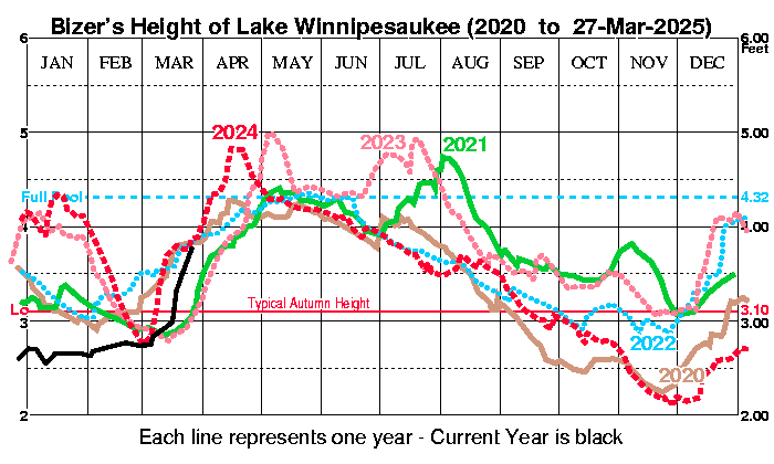
The September 26, 2001, reading was 2.61'. Today's was a tad lower at 2.60'. Since DES started keeping daily statistics in 1982, only the 1985 reading of 2.53' was lower for September 26th. Last edited by Bizer; 09-27-2016 at 07:39 AM. |
|
|
|
| The Following User Says Thank You to Bizer For This Useful Post: | ||
HellRaZoR004 (09-26-2016) | ||
|
09-26-2016, 08:09 PM
|
#21 |
|
Senior Member
Join Date: May 2004
Posts: 961
Thanks: 488
Thanked 274 Times in 175 Posts
|
Saw a WMUR vehicle at Fay's Boat Yard late this afternoon. Understand that they are doing a piece on the low lake level.
|
|
|
|
09-26-2016, 08:27 PM
|
#22 |
|
Senior Member
Join Date: Mar 2006
Location: Merrimack and Welch Island
Posts: 4,596
Thanks: 1,418
Thanked 1,705 Times in 1,109 Posts
|
Good place for it. I understand the keel sailboats are having trouble with the Smith Cove channel and I know people who had to pull their boats because not enough depth in slips. I had similar trouble at MVYC and had to move within the marina, then just decided to end the season early. Anybody hear anything from local businesses if they are suffering from people closing up early?
|
|
|
| The Following User Says Thank You to Descant For This Useful Post: | ||
SteveO123 (09-27-2016) | ||
|
09-27-2016, 07:57 PM
|
#24 |
|
Senior Member
Join Date: Mar 2016
Posts: 94
Thanks: 57
Thanked 22 Times in 11 Posts
|
There is a saying out there that "everything reverts to the mean". If memory serves me, most if not all mild winters and dry summers are followed by a heavy winter and drenching spring. The lake has thrived for hundreds/thousands of years - I can't wait to see how Mother Nature resolves this one. Looking forward to a monster winter!
|
|
|
|
09-28-2016, 08:15 PM
|
#25 | |
|
Senior Member
Join Date: Mar 2016
Posts: 94
Thanks: 57
Thanked 22 Times in 11 Posts
|
Quote:
http://www.wmur.com/news/drought-cau...aukee/41838238 Last edited by greeleyhill; 09-28-2016 at 08:56 PM. Reason: typo |
|
|
|
|
09-28-2016, 08:52 PM
|
#26 | |
|
Senior Member
Join Date: Feb 2012
Location: Tuftonboro
Posts: 1,275
Thanks: 196
Thanked 336 Times in 244 Posts
|
Quote:
|
|
|
|
|
09-28-2016, 10:57 PM
|
#27 |
|
Senior Member
Join Date: Jan 2003
Location: Alton Bay
Posts: 5,616
Blog Entries: 2
Thanks: 2,483
Thanked 1,988 Times in 1,088 Posts
|
I pulled my boat out today. I don't think I had more than two inches of water under the bow of my 25 ft Bowrider. Fortunately, Downing's Landing in Alton Bay still has good depth at the launch area. New concrete planks make for a nice smooth ramp.
Sent from my GT-P5210 using Tapatalk
__________________
I Live Here... I am always UPTHESAUKEE !!!! |
|
|
|
09-29-2016, 07:12 AM
|
#28 |
|
Senior Member
Join Date: Mar 2008
Location: Welch Island and The Taylor Community
Posts: 3,386
Thanks: 1,260
Thanked 2,148 Times in 983 Posts
|
Fay's sent out an advisory this morning for customers with a sailboat with draft over 5' to contact them right away as they may have trouble bringing their boat in.
|
|
|
|
09-29-2016, 08:23 AM
|
#29 |
|
Senior Member
Join Date: May 2012
Location: Litchfield/Gilford
Posts: 828
Thanks: 233
Thanked 224 Times in 131 Posts
|
Based on Bizer's page it looks as if we've hit 2001 levels....and still dropping..
|
|
|
| The Following 2 Users Say Thank You to HellRaZoR004 For This Useful Post: | ||
JerseyGuy (10-29-2016), motomurray (09-29-2016) | ||
|
09-29-2016, 08:27 AM
|
#30 |
|
Senior Member
Join Date: May 2004
Location: Coral Gables, winter; Long Island, summer
Posts: 1,366
Thanks: 966
Thanked 575 Times in 300 Posts
|
Be careful what you wish for. Keep an eye on ( now) tropical storm Matthew.
__________________
"You're only young once, but you can be immature forever." |
|
|
|
09-30-2016, 08:34 PM
|
#31 | |
|
Senior Member
Join Date: Oct 2009
Location: Meredith and FL
Posts: 99
Thanks: 177
Thanked 29 Times in 17 Posts
|
Quote:
|
|
|
|
|
10-01-2016, 12:10 PM
|
#32 | |
|
Senior Member
Join Date: Nov 2015
Posts: 578
Thanks: 1,497
Thanked 711 Times in 429 Posts
|
Quote:
The lake and a few others were only restricted for a few weeks not the entire season. |
|
|
|
|
10-01-2016, 01:31 PM
|
#33 | |
|
Senior Member
Join Date: Jun 2009
Posts: 119
Thanks: 0
Thanked 15 Times in 12 Posts
|
Quote:
|
|
|
|
|
10-01-2016, 02:01 PM
|
#34 | |
|
Senior Member
Join Date: May 2005
Posts: 504
Thanks: 5
Thanked 173 Times in 90 Posts
|
Quote:
|
|
|
|
|
10-01-2016, 04:41 PM
|
#35 | |
|
Moderator

|
Quote:
A submerged dock at Harilla Landing in Moultonboro in 1998 from this old thread:  The public docks in Wolfeboro's Back Bay were under water in 2005:  The Gazebo in Alton Bay in 2005: 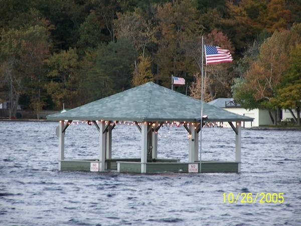 The walkway at the Bay Point Inn in Meredith in 2005: 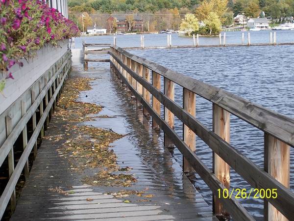
|
|
|
|
| The Following 4 Users Say Thank You to webmaster For This Useful Post: | ||
|
10-01-2016, 05:05 PM
|
#36 |
|
Senior Member
Join Date: Mar 2006
Location: Merrimack and Welch Island
Posts: 4,596
Thanks: 1,418
Thanked 1,705 Times in 1,109 Posts
|
If you want to talk about high water, please start a new thread.0
|
|
|
|
10-01-2016, 05:35 PM
|
#37 | |
|
Senior Member
Join Date: Feb 2005
Location: Gilford, NH and Florida
Posts: 3,159
Thanks: 749
Thanked 2,277 Times in 986 Posts
|
Quote:
I appreciate the site and the information, and enjoy all that it has to offer. The Webmaster does a GREAT job and works tirelessly to make it something we can all enjoy. I say, let him, or anyone, post whatever they want, whenever they would like as long as it fits within the guidelines of the site. Many threads take a turn from their initial subject but remain interesting and informative reading. I enjoy learning about, and from, the experiences of others and think the more posts the better! |
|
|
|
|
10-01-2016, 05:55 PM
|
#38 |
|
Senior Member

Join Date: Jan 2006
Posts: 6,945
Thanks: 795
Thanked 1,493 Times in 1,040 Posts
|
I agree that it was only for a few weeks. I never remember an entire lake no wake zone for the whole season.
|
|
|
|
10-01-2016, 06:16 PM
|
#39 | |
|
Senior Member
Join Date: Jan 2013
Posts: 764
Thanks: 771
Thanked 306 Times in 203 Posts
|
Quote:

__________________
GG |
|
|
|
| The Following User Says Thank You to gillygirl For This Useful Post: | ||
Hillcountry (10-03-2016) | ||
|
10-01-2016, 06:39 PM
|
#40 | |
|
Senior Member
Join Date: Jul 2002
Location: Massachusetts
Posts: 338
Thanks: 0
Thanked 250 Times in 83 Posts
|
Quote:
1998/06/13 3.99 1998/06/14 4.42 1998/06/15 4.70 1998/06/16 4.85 1998/06/17 5.16 1998/06/18 5.20 1998/06/19 5.44 1998/06/20 5.52 1998/06/21 5.53 1998/06/22 5.52 1998/06/23 5.48 1998/06/24 5.42 1998/06/25 5.37 1998/06/26 5.30 1998/06/27 5.37 1998/06/28 5.41 1998/06/29 5.34 1998/06/30 5.30 1998/07/01 5.25 1998/07/02 5.30 1998/07/03 5.27 1998/07/04 5.16 1998/07/05 5.15 1998/07/06 5.05 1998/07/07 5.02 1998/07/08 4.95 1998/07/09 4.86 1998/07/10 4.77 1998/07/11 4.66 1998/07/12 4.54 1998/07/13 4.45 1998/07/14 4.36 1998/07/15 4.29 |
|
|
|
|
10-01-2016, 07:19 PM
|
#41 | |
|
Senior Member
Join Date: Mar 2008
Location: Welch Island and The Taylor Community
Posts: 3,386
Thanks: 1,260
Thanked 2,148 Times in 983 Posts
|
Quote:
|
|
|
|
|
10-01-2016, 11:21 PM
|
#42 |
|
Senior Member

Join Date: Jul 2004
Location: pine island of course!
Posts: 411
Thanks: 261
Thanked 251 Times in 115 Posts
|
Here are some photos around Pine Island of the high water the early part of that summer of '98
Somewhere between what we had then... and what we have now... would be nice! -PIG |
|
|
| The Following 3 Users Say Thank You to Pine Island Guy For This Useful Post: | ||
|
10-02-2016, 02:31 PM
|
#43 |
|
Junior Member

Join Date: Apr 2007
Posts: 9
Thanks: 0
Thanked 3 Times in 1 Post
|
|
|
|
|
10-02-2016, 04:25 PM
|
#44 |
|
Senior Member
Join Date: Apr 2005
Location: Burlington Ma / Laconia NH
Posts: 396
Thanks: 154
Thanked 201 Times in 97 Posts
|
We emptied out "The Breeze" today to put her away for the Winter. The water level made safe boating in and out of Mountain View a little questionable. We had an awesome season this year and have no regrets about the early haul out. We had sunny weekends almost EVERY weekend since Motorcycle Week so no complaints from us!! Great friends great memories awesome Summer. Bring on the pumpkins!!
The Breeze Wave 'cuz I'll be wavin' back |
|
|
|
10-02-2016, 05:32 PM
|
#45 | |
|
Senior Member

Join Date: Jul 2014
Posts: 6,545
Thanks: 1,184
Thanked 2,180 Times in 1,355 Posts
|
Quote:
Sent from my XT1528 using Tapatalk |
|
|
|
|
10-02-2016, 11:59 PM
|
#46 |
|
Member
Join Date: Jan 2015
Posts: 47
Thanks: 2
Thanked 7 Times in 7 Posts
|
We're probably gonna be in for a very snowy winter this year. That will fill the lake up
|
|
|
|
10-03-2016, 03:00 PM
|
#47 |
|
Senior Member

Join Date: Apr 2004
Posts: 5,075
Thanks: 215
Thanked 903 Times in 509 Posts
|
In 98 the no wake was lifted for the July 4th weekend. Many were not happy as the level was still real high.
__________________
SIKSUKR |
|
|
|
10-03-2016, 03:50 PM
|
#48 |
|
Senior Member
Join Date: May 2004
Posts: 961
Thanks: 488
Thanked 274 Times in 175 Posts
|
Cruised past Indian Head Rock located on the east shore of Camp Lawrence near the south end of Bear Island on our return to the mainland today. The painted Indian head is high and dry - - enough dry surface to see a belt if he had one! Also, nipple rock, located off the northeast end of Round Island, is now quite revealing.

|
|
|
|
10-03-2016, 04:19 PM
|
#49 |
|
Senior Member
Join Date: Mar 2006
Location: Merrimack and Welch Island
Posts: 4,596
Thanks: 1,418
Thanked 1,705 Times in 1,109 Posts
|
We're pretty much done for the season so no more cruising. Would love it if people posted pictures here of things like this that we rarely see. Great opportunity missed to put new rubber facing on dock posts so it goes down lower on the post.
|
|
|
|
10-03-2016, 06:14 PM
|
#50 |
|
Senior Member
Join Date: Jun 2008
Location: Portsmouth. RI
Posts: 2,231
Thanks: 400
Thanked 460 Times in 308 Posts
|
Just got back from two weeks plus..at the lake today and I read this thread.
BEFORE we left for the lake, I was was watching the WolfeCam a little after NOON..on a day which I can't recall... and The Mount was "sitting" there at the pier at Wolfeboro with no one apparently aboard...and un-moving. The Mount is usually gone from there at 1130 AM. During our vacation, we learned that the Mount was Aground at the dock for awhile while a large number of charter passengers were either dis- embarked..OR moved to another position on the ship to change the weight distribution...or something. Maybe four days ago I was observing the Mount approach the dock at Wolfeboro. She made what I thought was a wide approach and couldn't make it in close enough to "walk" the stern over to the aft "dolphin". She had the bow and spring lines ashore..and the gangway aboard. No Go. She aborted the operation..tossed off all lines and the gangway and backed out into the bay. The second attempt was successful. (There was a Senior Captain aboard.)  I have spoken with him in the past. He reminds me of the last Master Chief I served with in the navy. Completely competent. I have spoken with him in the past. He reminds me of the last Master Chief I served with in the navy. Completely competent. My assessment was ..Maybe there was a "Captain in Training" at the Con.........OR... a berm under the boat. (Low Water). They could not get the boat to "Walk" over to the "Dolphin". Just an observation from an old Navy man. NB Last edited by NoBozo; 10-03-2016 at 07:24 PM. |
|
|
|
10-11-2016, 03:55 PM
|
#51 |
|
Senior Member

Join Date: Mar 2003
Location: FL, Bear Is.
Posts: 193
Thanks: 52
Thanked 75 Times in 46 Posts
|
Just found this on the cruisenh.com, regarding the Mount's ports of call:
IMPORTANT SCHEDULE CHANGE: Due to unusually low lake levels, we are unable to dock in Wolfeboro. For the remainder of the season we will stop in Alton Bay instead of Wolfeboro. |
|
|
|
10-11-2016, 04:07 PM
|
#52 | |
|
Senior Member
Join Date: Feb 2008
Location: Gilford, NH / Welch Island
Posts: 6,533
Thanks: 2,455
Thanked 5,468 Times in 2,143 Posts
|
Quote:
Dan
__________________
It's Always Sunny On Welch Island!!
|
|
|
|
|
10-11-2016, 04:57 PM
|
#53 | |
|
Senior Member
Join Date: May 2006
Location: Texas, Lake Ray Hubbard and NH, Long Island Winnipesaukee
Posts: 2,970
Thanks: 1,064
Thanked 912 Times in 539 Posts
|
Quote:
Remember She is 230' long.... I was looking at the fact that the Dam has been closed now, for the down stream draw down as normal.... And even with the rain this weekend, the lake really isn't rising.....
__________________
Life is about how much time you can spend relaxing... I do it on an island that isn't really an island..... |
|
|
|
| The Following User Says Thank You to LIforrelaxin For This Useful Post: | ||
ishoot308 (10-11-2016) | ||
|
10-11-2016, 07:13 PM
|
#54 |
|
Senior Member
Join Date: Jun 2008
Location: Portsmouth. RI
Posts: 2,231
Thanks: 400
Thanked 460 Times in 308 Posts
|
I spoke with a ships officer (three stripes) about the draft of the ship. The bow looks like it draws maybe four feet..visually...my observation. He told me the stern draws nearly nine feet..."at cruise speed". ie.The ship "squats" at speed. Although imprecise....That makes perfect sense.
The decision to skip Wolfeboro makes sense. If the ship were to get stuck at the pier...on a berm ("sand bar")...under the ship,....towing her off would be an unlikely event...there are no "Tugboats" on the lake powerful enough to tow her off. A berm in the Wrong Place under the keel...Uneven support ..with the lake level going down "could"... Break The Back of this old ship.  NB NB
|
|
|
|
10-11-2016, 07:47 PM
|
#55 |
|
Senior Member
Join Date: Jun 2008
Location: Portsmouth. RI
Posts: 2,231
Thanks: 400
Thanked 460 Times in 308 Posts
|
The hull of This Mount Washington was originally the Chateaugay, built on Lake Champlain in 1888. The Chateaugay was a Walking Beam Side Wheeler Steamer. She was transported over to Winni in sections on rail cars in 1940....To become today's M/S Mount Washington.
There is more history ..for another time. NB |
|
|
|
10-11-2016, 08:18 PM
|
#56 | |
|
Senior Member
Join Date: Feb 2015
Posts: 848
Thanks: 116
Thanked 212 Times in 134 Posts
|
Quote:
Interestingly though, they link to a thread on this very forum for More history about the Chateaguay http://www.cruisenh.com/history.php |
|
|
|
|
10-22-2016, 08:23 AM
|
#57 |
|
Senior Member
Join Date: Jan 2003
Location: Alton Bay
Posts: 5,616
Blog Entries: 2
Thanks: 2,483
Thanked 1,988 Times in 1,088 Posts
|
Hopefully this link will post ok. Picture in today's Laconia Daily Sun shows a boat that was moored in Buzzell Cove, high and dry. Here is the link: http://html5.pagesuite-professional....b-2cb28cf04cd8
Sent from my GT-P5210 using Tapatalk
__________________
I Live Here... I am always UPTHESAUKEE !!!! |
|
|
|
10-22-2016, 09:06 AM
|
#58 |
|
Senior Member
Join Date: Nov 2013
Posts: 394
Thanks: 20
Thanked 131 Times in 94 Posts
|
That link wouldn't work for me.
|
|
|
|
10-22-2016, 09:08 AM
|
#59 |
|
Senior Member
Join Date: Jul 2014
Posts: 6,545
Thanks: 1,184
Thanked 2,180 Times in 1,355 Posts
|
 Sent from my XT1528 using Tapatalk |
|
|
| The Following 2 Users Say Thank You to thinkxingu For This Useful Post: | ||
aquabones (10-27-2016), upthesaukee (10-22-2016) | ||
|
10-22-2016, 09:19 AM
|
#60 |
|
Senior Member

Join Date: Jan 2012
Posts: 2,193
Thanks: 63
Thanked 764 Times in 497 Posts
|
Was the boat "moored" in 2" of water?
I think there's more back story to this picture than the lake is low. |
|
|
|
10-22-2016, 10:06 AM
|
#61 | |
|
Senior Member
Join Date: Jan 2003
Location: Alton Bay
Posts: 5,616
Blog Entries: 2
Thanks: 2,483
Thanked 1,988 Times in 1,088 Posts
|
Quote:
Remember, the lake is more than a foot lower than the median for this time of year. I also noticed that the boat appears to be a jet drive, like a Yamaha, and doesn't have the draft that an I/O or OB would have. Still, ya gotta ask: "What the heck were you thinking? "  Sent from my GT-P5210 using Tapatalk
__________________
I Live Here... I am always UPTHESAUKEE !!!! |
|
|
|
|
10-22-2016, 11:32 AM
|
#62 | |
|
Senior Member
Join Date: Mar 2008
Location: Bear Island/Merrimack
Posts: 807
Thanks: 58
Thanked 203 Times in 130 Posts
|
Quote:
Here's the DES water levels for the past few months: 10/21 502.25 9/21 502.75 8/21 503.30 7/21 503.80 |
|
|
|
|
10-22-2016, 04:01 PM
|
#63 |
|
Senior Member
Join Date: Jun 2007
Location: Moultonborough
Posts: 585
Thanks: 53
Thanked 107 Times in 82 Posts
|
Try this link.
http://www.laconiadailysun.com/newsx...land-low-water Might need to be subscriber for other link. |
|
|
|
10-22-2016, 06:03 PM
|
#64 | |
|
Senior Member
Join Date: Nov 2013
Posts: 394
Thanks: 20
Thanked 131 Times in 94 Posts
|
Quote:
|
|
|
|
| The Following User Says Thank You to Lakeboater For This Useful Post: | ||
upthesaukee (10-22-2016) | ||
|
10-27-2016, 06:37 PM
|
#65 |
|
Senior Member

Join Date: Jul 2013
Posts: 74
Thanks: 53
Thanked 16 Times in 5 Posts
|
why didn't the water level on Squam Lake not get as low as on Winnipeasauke?
|
|
|
|
10-27-2016, 06:46 PM
|
#66 | |
|
Senior Member
Join Date: Aug 2011
Location: Las Vegas, NV and Moultonborough, NH
Posts: 404
Thanks: 27
Thanked 96 Times in 80 Posts
|
Quote:
|
|
|
|
|
10-27-2016, 07:10 PM
|
#67 |
|
Senior Member
|
Squam's only outlet dam is located at west end of Little Squam Lake in Ashland. The outflow discharge water flows into the Squam River that travels west to the Pemigewasset River, and the dam outflow can easily be seen from nearby Route 25/3, or from River St in Ashland. The dam looks like a well designed and engineered dam construction made with concrete and steel and may even have a hydro-electric turbine in the little shed at the center top of the dam.
Like guess what ..... there is no Squam outflow water discharge as of today. The dam is not discharging any water. Do not know who controls the Squam Dam .... my guess would be the NH-DES. http://www.squamlakes.org/watershed-...r-service-area http://www.nhpr.org/post/maintaining...rs-environment The NH Dept Environmental Service - Lakeport Dam, Lake Winnipesaukee's only outflow dam, located in Laconia is required to maintain a minimum water outflow to supply water to the septic treatment plant in Franklin, plus for some hydro-electric turbines. Without a steady water supply the waste water treatment facility in Franklin could get all plugged up ....... what the poop! You know that a sewerage treatment plant without enough water is just a whole lot of poop. If you have a deep drilled well, maybe you want to run a garden hose from your house to the lake to raise the level of the big lake!
__________________
 .... Banned for life from local thrift store! .... Banned for life from local thrift store!
Last edited by fatlazyless; 10-28-2016 at 11:11 AM. |
|
|
|
10-28-2016, 04:47 AM
|
#68 | |
|
Senior Member

Join Date: Jan 2009
Location: Meredith
Posts: 310
Thanks: 614
Thanked 220 Times in 138 Posts
|
Quote:
|
|
|
|
|
10-28-2016, 09:43 AM
|
#69 | |
|
Senior Member
Join Date: Apr 2015
Location: Wolfeboro
Posts: 162
Thanks: 268
Thanked 80 Times in 33 Posts
|
Quote:
|
|
|
|
|
10-28-2016, 11:45 AM
|
#70 | |
|
Senior Member
Join Date: May 2006
Location: Texas, Lake Ray Hubbard and NH, Long Island Winnipesaukee
Posts: 2,970
Thanks: 1,064
Thanked 912 Times in 539 Posts
|
Quote:
__________________
Life is about how much time you can spend relaxing... I do it on an island that isn't really an island..... |
|
|
|
|
11-03-2016, 11:55 AM
|
#71 |
|
Senior Member

Join Date: Aug 2004
Location: Moultonborough & CT
Posts: 2,550
Thanks: 1,072
Thanked 672 Times in 369 Posts
|
Thought I would post a picture of our shoreline. The stairs are normally covered up to the 3rd level from the bottom. Lowest lake level I can remember in 60 years. I do have family pictures of this area, with a similar level back in the early 1900s, but that was way before my time.
|
|
|
| The Following User Says Thank You to Pineedles For This Useful Post: | ||
Whimsey (11-03-2016) | ||
|
11-03-2016, 01:15 PM
|
#72 |
|
Senior Member

Join Date: Jun 2008
Posts: 50
Thanks: 1
Thanked 2 Times in 2 Posts
|
Hello
how many inches is the lake down as of today 25 +/- inches still or lower thanks |
|
|
|
11-03-2016, 01:21 PM
|
#73 |
|
Senior Member
Join Date: Jul 2002
Location: Central MA
Posts: 2,358
Thanks: 18
Thanked 577 Times in 183 Posts
|
The lake has been hovering at 502.30 give or take an inch for a while. You can see the hourly levels by clicking on the lake levels links from http://www.rattlesnakecam.com/watch.htm.
You can also go to Bizer's site at http://www.Bizer.com and see the weekly levels and a super chart of the levels over the last several years. He typically updates this on Thursday's with extra updates when something unusual happens. I have a picture of my dock in 2001 about this time of year and the lake was lower than it is today. IG
__________________
Island Girl ....... Make Lemonade Last edited by Island Girl; 11-03-2016 at 01:22 PM. Reason: fixed link |
|
|
|
11-03-2016, 04:51 PM
|
#74 |
|
Senior Member

Join Date: Oct 2006
Location: Valencia, Spain (formerly Rattlesnake Isle)
Posts: 389
Thanks: 135
Thanked 142 Times in 82 Posts
|
Seems that this would be an ideal time to fix those things that are normally below the water - stairs, walls, and in certain cases previously pictured, moorings.
|
|
|
|
11-03-2016, 05:47 PM
|
#75 | |
|
Senior Member
Join Date: Jan 2003
Location: Alton Bay
Posts: 5,616
Blog Entries: 2
Thanks: 2,483
Thanked 1,988 Times in 1,088 Posts
|
Quote:
Sent from my GT-P5210 using Tapatalk
__________________
I Live Here... I am always UPTHESAUKEE !!!! |
|
|
|
|
11-03-2016, 07:41 PM
|
#76 |
|
Senior Member
Join Date: Feb 2014
Posts: 273
Thanks: 119
Thanked 62 Times in 40 Posts
|
Winnisquam has been drawn down lower and longer than expected, but looks like it's on the rise the past few days. The dogs have really liked having beach to run on, but after a few weekends of sand in the house I'm ready to have the water back to the rocks.
")
|
|
|
|
11-03-2016, 07:47 PM
|
#77 |
|
Senior Member
Join Date: Feb 2003
Location: Moultonboro, NH
Posts: 1,692
Blog Entries: 1
Thanks: 356
Thanked 646 Times in 294 Posts
|
The rain today finally got some seasonal streams running, which had remained dry in the past few heavy downpours. Perhaps the ground is finally starting to recharge and runoff to the lake will increase.
__________________
-lg |
|
|
|
| Bookmarks |
|
|


 Linear Mode

