

|
|
|
|
|
|||||||
| Home | Forums | Gallery | Webcams | Blogs | YouTube Channel | Classifieds | Calendar | Register | FAQ | Donate | Members List | Today's Posts | Search |
 |
|
|
Thread Tools | Display Modes |
 02-20-2022, 05:31 PM
|
#1 |
|
Senior Member
Join Date: Aug 2006
Location: Meredith Bay/MA
Posts: 74
Thanks: 117
Thanked 47 Times in 17 Posts
|
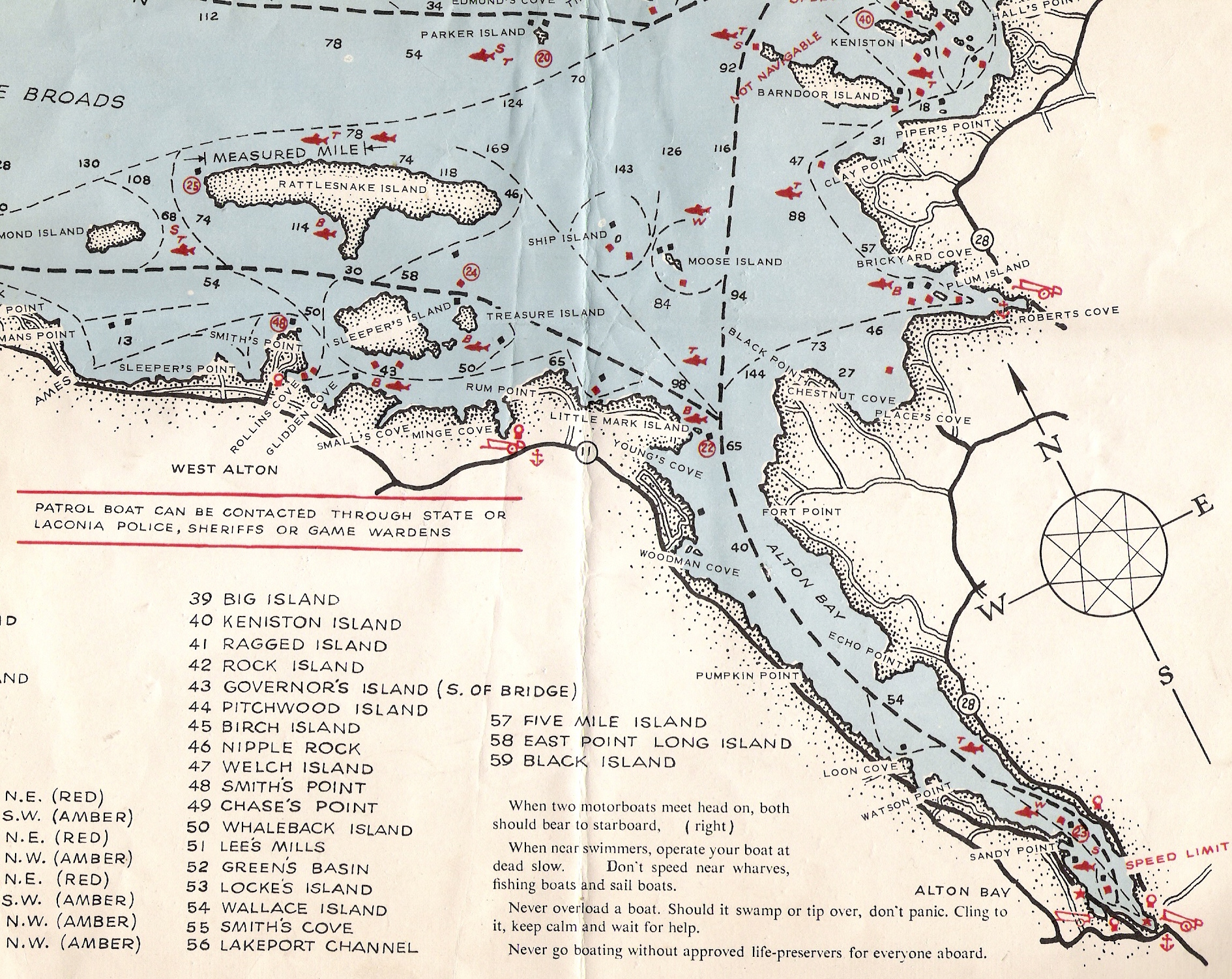
I acquired these maps a few months ago and had them mounted. One is a 1951 Winn Navigation Chart and the other is a 1902 White Mountain Topo Map including Winn. Had to reduce the size to get them to load so they will not be clear if you zoom in on them.
|

|

|
| The Following 3 Users Say Thank You to DougNH For This Useful Post: | ||
|
02-20-2022, 06:20 PM
|
#2 |
|
Senior Member
|
On the 1951-map is interesting to see a measured mile on the north side of Rattlesnake.
Anyone know were the boundary markers on the land or floating spars in the water?
__________________
... down and out, liv'n that Walmart side of the lake! |
|
|
|
|
02-20-2022, 09:47 PM
|
#3 | |
|
Senior Member
Join Date: Apr 2004
Location: Whortleberry Island
Posts: 107
Thanks: 15
Thanked 37 Times in 24 Posts
|
They were markers on land with "Measured Mile" written on them. I guess back when most boats didn't have speedometers? I remember seeing them and thinking it was pretty cool. If you were boating by and happened to have a stopwatch you could calculate how fast you were going.
") Were they some kind of official markers or like the Barber's Pole? Quote:
|
|
|
|
|
|
02-20-2022, 10:51 PM
|
#4 | |
|
Senior Member
Join Date: Mar 2006
Location: Merrimack and Welch Island
Posts: 4,030
Thanks: 1,208
Thanked 1,509 Times in 982 Posts
|
Quote:
There were similar signs at each end of the Weirs Channel that your transit time should not be less than three (?) minutes from one sign to the next. The northern sign was just before the bridge, so many operated on the assumption that the NWZ started at the bridge, not at the outermost buoy (piling at that time) The 1951 chart (I use a 1962 version) was published by the Public Utilities Commission a predecessor to Marine Patrol. For the most part, the rocks haven't changed, so the "old" chart is valid, except where new buoys have been added. For me, the Bizer chart is cluttered with extra information that makes it difficult to read while underway. Erratic type fonts add to that confusion, so my second choice is the green (Dunphy?) chart. Nevertheless, I carry a Bizer chart on board too. Someday, I'll probably set up a GPS, but not needed yet. The rocks haven't moved since I started navigating as a kid some decades ago. |
|
|
|
|
|
02-21-2022, 05:53 AM
|
#5 | |
|
Senior Member
Join Date: Jan 2003
Location: Alton Bay
Posts: 5,547
Blog Entries: 2
Thanks: 2,397
Thanked 1,918 Times in 1,061 Posts
|
Quote:
Dave
__________________
I Live Here... I am always UPTHESAUKEE !!!! |
|
|
|
|
| Sponsored Links |
|
|
|
02-21-2022, 08:41 AM
|
#6 |
|
Senior Member

Join Date: Jul 2002
Location: Rock Haven Lake - West Newfield, ME
Posts: 5,359
Thanks: 374
Thanked 1,041 Times in 489 Posts
|
Map showing measured mile off Rattlesnake - 1962 Fishing map

__________________
|
|
|
|
|
02-21-2022, 08:45 AM
|
#7 |
|
Senior Member
Join Date: Jul 2002
Location: Rock Haven Lake - West Newfield, ME
Posts: 5,359
Thanks: 374
Thanked 1,041 Times in 489 Posts
|
............
__________________
|
|
|
|
|
02-21-2022, 09:12 AM
|
#8 |
|
Member

Join Date: Apr 2019
Location: Northwest Connecticut
Posts: 37
Thanks: 97
Thanked 31 Times in 14 Posts
|
Slightly off topic, but does anyone know of a map that shows Wini that includes the various names people use for areas of the lake (The Witches, The Broads, etc.)? I want to hang a Wini map on my office wall, but the Bizer's map is a bit to large (I know I can get a PDF and print myself) and a bit more detailed then I was looking for since I'm not piloting my office on the lake (stretch goal though).
*Edit: McDude's map looks like it would be perfect! Where can I get one? Thanks. |
|
|
|
|
| Bookmarks |
|
|


 Linear Mode

