

|
|
|
|
|
|||||||
| Home | Forums | Gallery | Webcams | Blogs | YouTube Channel | Classifieds | Calendar | Register | FAQ | Donate | Members List | Today's Posts | Search |
 |
|
|
Thread Tools | Display Modes |
 12-11-2008, 06:08 PM
|
#1 |
|
Senior Member

Join Date: Jul 2002
Location: Rock Haven Lake - West Newfield, ME
Posts: 5,361
Thanks: 374
Thanked 1,044 Times in 490 Posts
|
Moo!
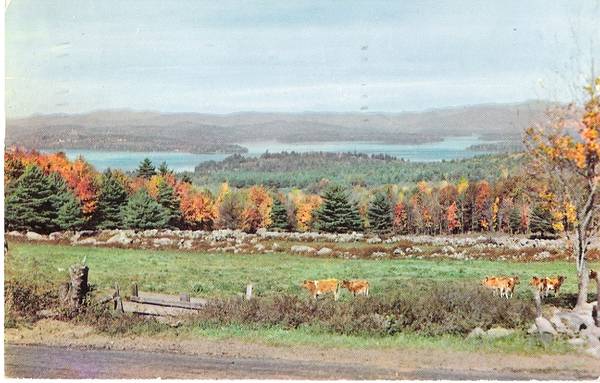 This card was postmarked in 1955. Can anyone identify the location?
__________________
|

|

|
|
12-11-2008, 06:18 PM
|
#2 |
|
Senior Member

Join Date: Apr 2004
Location: NJ
Posts: 518
Thanks: 62
Thanked 42 Times in 23 Posts
|
Well, I am no expert, but that looks like Alton Bay and Echo Point in the backround there. Somewhere in Gilford, maybe, off Route 11???
nj2nh
__________________

|
|
|
|
|
12-11-2008, 07:50 PM
|
#3 | |
|
Deceased Member

Join Date: Jul 2006
Location: Gilford, NH
Posts: 2,311
Thanks: 1,070
Thanked 2,054 Times in 497 Posts
|
Quote:
Looks like what you would see from 11A in Gilford. I pulled up google terrain map in the area of intersection of 11A and Poor Farm Rd. Gilford. Tried to paste it into the thread but I messed it up somehow. Some of the map experts on here will figure it out.
__________________
"Before you criticize someone, walk a mile in his shoes. That way, if he gets angry he'll be a mile away and barefoot!" unknown |
|
|
|
|
|
12-12-2008, 09:33 AM
|
#5 |
|
Member
Join Date: May 2004
Location: Gilford, NH
Posts: 43
Thanks: 8
Thanked 10 Times in 4 Posts
|
If you look closely, it appears that Red Hill is in the upper right just behind and to the left of the tree. You have to look closely, because it is not the highest ridge; Red Hill is actually set in front of that ridge.
So if that is Red Hill, then my guess is that the view is loooking up Moultonborough Bay. Perhaps that is Buzzell Cove right there in the middle. |
|
|
|
| Sponsored Links |
|
|
|
12-12-2008, 09:58 AM
|
#6 |
|
Senior Member

Join Date: Sep 2004
Location: Moultonborough when I can / RI
Posts: 699
Thanks: 180
Thanked 38 Times in 22 Posts
|
my guess is
Parade Road in Meredith overlooking Lake Waukewan ? |
|
|
|
|
12-12-2008, 10:06 AM
|
#7 |
|
Senior Member
Join Date: Jul 2002
Location: Rock Haven Lake - West Newfield, ME
Posts: 5,361
Thanks: 374
Thanked 1,044 Times in 490 Posts
|
NHKathy: Postcard photographers were often from out of town and had no idea what they were photographing so many times you get some amusing notes on the reverse the card. Keeping that in mind, this card is labelled "Pastoral Scene on Lake Winnipesaukee"
__________________
|
|
|
|
|
12-12-2008, 05:43 PM
|
#9 |
|
Senior Member

Join Date: Jul 2002
Location: Alton Bay on the mountain by a lake
Posts: 2,023
Thanks: 563
Thanked 444 Times in 311 Posts
|
It looks like Dana Morse's farm up on Alton Mountain before the trees grew up.

__________________
 There is nothing better than living on Alton Mountain & our grand kids visits. There is nothing better than living on Alton Mountain & our grand kids visits.
|
|
|
|
|
12-12-2008, 06:57 PM
|
#10 |
|
Deceased Member

Join Date: Jul 2002
Posts: 1,701
Thanks: 115
Thanked 25 Times in 13 Posts
|
Yes that looks like Echo point but there is no large cove across from it in Alton Bay.I think that it is Black Island and you are looking up Moultonborough bay.
RLW yes it does look like Morse's fence but its not Alton Bay. |
|
|
|
|
12-15-2008, 12:43 PM
|
#11 | |
|
Senior Member

Join Date: Sep 2003
Posts: 1,943
Thanks: 23
Thanked 111 Times in 51 Posts
|
Quote:
__________________
Mee'n'Mac "Never attribute to malice that which can be explained by simple stupidity or ignorance. The latter are a lot more common than the former." - RAH |
|
|
|
|
|
12-15-2008, 01:44 PM
|
#12 |
|
Senior Member

Join Date: Aug 2004
Location: Moultonborough & CT
Posts: 2,535
Thanks: 1,059
Thanked 652 Times in 363 Posts
|
Prior to the Belgium Belted Galloways that now reside in Center Harbor, Guernsey cows were at the Longwood Farms. We could be looking ESE at the entrance to Center Harbor Bay.
|
|
|
|
|
12-15-2008, 04:11 PM
|
#13 |
|
Junior Member
Join Date: Apr 2004
Posts: 10
Thanks: 0
Thanked 0 Times in 0 Posts
|
It look like the area by Governor Wentworth Hwy or Rt109 looking down to Sawyer Point Rd off of Caverly Point Rd in Tuftonboro.
|
|
|
|
|
12-15-2008, 09:54 PM
|
#14 |
|
Senior Member
Join Date: Apr 2006
Posts: 332
Thanks: 0
Thanked 51 Times in 26 Posts
|
I wish it were the view from the front porch of my dream farmhouse...
|
|
|
|
|
12-16-2008, 04:05 PM
|
#15 |
|
Senior Member
Join Date: Apr 2008
Posts: 184
Thanks: 2
Thanked 42 Times in 34 Posts
|
I think it is Rt. 109 in Tuftonboro between 20 Mile Bay and Melvin Village close to Copps Hill and the entrance to the old Wawbeek.
|
|
|
|
|
12-18-2008, 11:28 AM
|
#16 |
|
Senior Member

Join Date: Jul 2004
Posts: 2,974
Thanks: 246
Thanked 736 Times in 438 Posts
|
Since it was obviously early to mid autumn based on the foliage and the sun was pretty close to peak height for that time of year, based on the short shadows, the location of the shadows indicate the camera was facing west to northwest. There is no way the shot could have been taken looking easterly, so that eliminates Echo Point.
It looks like it was taken near the intersection of 109 and 109A just north of 20 Mile Bay. The alignment of the tip of Haley Point and the entrance to Buzzell Cove on the right side of the picture helps define this location. Everything else fits except Black Island looks more like a peninsula than an island and the scale of Buzzell Cove may be a little off. |
|
|
|
|
12-18-2008, 07:56 PM
|
#17 | |
|
Senior Member
Join Date: Aug 2004
Location: Moultonborough & CT
Posts: 2,535
Thanks: 1,059
Thanked 652 Times in 363 Posts
|
Quote:
|
|
|
|
|
|
12-18-2008, 11:35 PM
|
#18 |
|
Senior Member
Join Date: Feb 2008
Location: Gilford, NH / Welch Island
Posts: 5,932
Thanks: 2,290
Thanked 4,943 Times in 1,918 Posts
|
Here's my guess...I believe the picture was taken in a Northeast direction. I think it was taken from one of the old farms off route 3 in Laconia, possibly where Funspot is today. The start of Meredith Bay would be on the left and the point sticking out in the center left would be Spindle point. Pitchwood island is visible in the background at center right. Eagle island is on the right and the Ossipee mountains (Mount Roberts, etc) in the background.
That's my story and I'm sticking to it! Dan |
|
|
|
|
12-19-2008, 12:00 AM
|
#19 |
|
Senior Member

Join Date: Nov 2002
Location: The Lakes, Central NH. and Dallas/Fort Worth TX.
Posts: 3,694
Blog Entries: 3
Thanks: 3,069
Thanked 472 Times in 236 Posts
|
ishoot308 has solved the mystery!
So far, you have my vote!
__________________
trfour Always Remember, The Best Safety Device In The Boat, or on a PWC Snowmobile etc., Is YOU! Safe sledding tips and much more; http://www.snowmobile.org/snowmobiling-safety.html |
|
|
|
|
12-19-2008, 06:13 AM
|
#20 | |
|
Senior Member

Join Date: Jan 2005
Location: Florida (Sebring & Keys), Wolfeboro
Posts: 5,788
Thanks: 2,085
Thanked 742 Times in 532 Posts
|
Quote:
I think that's Doctor's Island to the left, and the scene is Sebago Lake.  
__________________
Every MP who enters Winter Harbor will pass by my porch of 67 years... 
|
|
|
|
|
|
12-23-2008, 06:00 PM
|
#21 | |
|
Senior Member
Join Date: Jul 2002
Location: Rock Haven Lake - West Newfield, ME
Posts: 5,361
Thanks: 374
Thanked 1,044 Times in 490 Posts
|
Quote:
Here's another one for you. Any ideas? 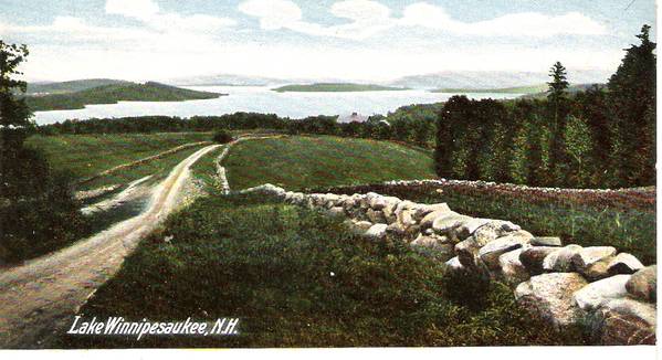 P.S. No Postmark
__________________
|
|
|
|
|
|
12-23-2008, 07:33 PM
|
#22 |
|
Senior Member
Join Date: Apr 2005
Location: Wolfeboro, New Hampshire is my home, 24-7-365
Posts: 1,686
Thanks: 1,047
Thanked 336 Times in 189 Posts
|
It looks like Robert's Cove Road.
|
|
|
|
|
12-23-2008, 10:34 PM
|
#23 |
|
Senior Member
Join Date: Aug 2007
Posts: 446
Thanks: 70
Thanked 57 Times in 40 Posts
|
Looks like Roberts Cove area. Looks like the point the Bahr's are on.
|
|
|
|
|
12-24-2008, 09:24 AM
|
#24 |
|
Member
Join Date: Mar 2007
Location: GIW NH
Posts: 41
Thanks: 0
Thanked 0 Times in 0 Posts
|
go with the morse farm area.
The more I follow this thread the more I second guess my first instinct. DIVULGE!, DIVULGE! Your killin me Mc'D Please? In the holiday spirit and all that? 
|
|
|
|
|
12-24-2008, 11:17 AM
|
#25 | |
|
Senior Member
Join Date: Jul 2002
Location: Rock Haven Lake - West Newfield, ME
Posts: 5,361
Thanks: 374
Thanked 1,044 Times in 490 Posts
|
Quote:
Here's a photo of Robert's Cove Road from a similar angle....what do you think? 
__________________
|
|
|
|
|
|
12-29-2008, 06:27 PM
|
#26 | |
|
Senior Member

Join Date: Apr 2004
Location: Whortleberry Island
Posts: 81
Thanks: 130
Thanked 20 Times in 10 Posts
|
Quote:
My Aunt Mary has donated a 431-acre reservation to the New Hampshire Forests. It is going to be named after my grandparents, Evelyn H. and Albert D. Morse Sr. Preserve. There is a beautiful view of Lake Winnipesaukee from the top of the Blueberry Hill. The Forest Society is still formulating its plan for the property, including public access logistics.
|
|
|
|
|
| The Following User Says Thank You to Dog's Ear For This Useful Post: | ||
Rattlesnake Gal (11-12-2011) | ||
|
12-29-2008, 06:49 PM
|
#27 | |
|
Senior Member
Join Date: Jul 2002
Location: Alton Bay on the mountain by a lake
Posts: 2,023
Thanks: 563
Thanked 444 Times in 311 Posts
|
Quote:
My thanks to Aunt Mary for her generosity.
__________________
There is nothing better than living on Alton Mountain & our grand kids visits.
|
|
|
|
|
|
12-30-2008, 09:40 AM
|
#28 | |
|
Member
Join Date: Mar 2007
Location: GIW NH
Posts: 41
Thanks: 0
Thanked 0 Times in 0 Posts
|
Quote:
|
|
|
|
|
|
12-30-2008, 11:36 AM
|
#29 |
|
Junior Member
Join Date: Oct 2008
Location: Melvin Village
Posts: 17
Thanks: 0
Thanked 4 Times in 3 Posts
|
The picture in question looks to me like it was taken at the Tuftonboro four corners, lookig towards Melvin Bay. Also on into Moultonboro.
|
|
|
|
|
12-30-2008, 04:12 PM
|
#30 | |
|
Senior Member

Join Date: Apr 2004
Posts: 593
Thanks: 283
Thanked 427 Times in 139 Posts
|
Quote:
I think we need FlyGuy to take a picture while flying low over Tuftonboro four corners to help us out. Hey BJAM - Have you read the PM I sent you?
__________________
Lake Winni - The only place I want to be during the summer.
|
|
|
|
|
|
12-30-2008, 04:18 PM
|
#31 |
|
Senior Member
Join Date: Apr 2004
Posts: 593
Thanks: 283
Thanked 427 Times in 139 Posts
|
Every time I click on this thread, it positions me around post #5. No other thread does that to me. I view threads in reverse post order.
__________________
Lake Winni - The only place I want to be during the summer.
|
|
|
|
|
12-30-2008, 04:41 PM
|
#32 |
|
Senior Member

Join Date: Feb 2004
Location: Mountonboro
Posts: 200
Thanks: 12
Thanked 0 Times in 0 Posts
|
Even when I clicked on the reply button, I was taken back to that early post.

|
|
|
|
|
12-30-2008, 05:02 PM
|
#33 | |
|
Junior Member
Join Date: Oct 2008
Location: Melvin Village
Posts: 17
Thanks: 0
Thanked 4 Times in 3 Posts
|
Quote:
|
|
|
|
|
|
12-30-2008, 06:38 PM
|
#34 | |
|
Senior Member

Join Date: Apr 2004
Location: Kensington, NH and Paugus Bay Marina
Posts: 656
Thanks: 323
Thanked 17 Times in 13 Posts
|
Quote:
__________________
On the boat is always waterfront! |
|
|
|
|
|
12-30-2008, 07:44 PM
|
#35 | |
|
Senior Member
Join Date: Sep 2008
Posts: 66
Thanks: 0
Thanked 0 Times in 0 Posts
|
Quote:
|
|
|
|
|
|
12-30-2008, 07:48 PM
|
#36 |
|
Junior Member
Join Date: Oct 2008
Location: Melvin Village
Posts: 17
Thanks: 0
Thanked 4 Times in 3 Posts
|
Waterbaby, Thanks alot for the info. I will figure it out after awhile. It's fun so far.
|
|
|
|
|
12-30-2008, 08:28 PM
|
#37 | ||||
|
Senior Member
Join Date: Jan 2005
Location: Florida (Sebring & Keys), Wolfeboro
Posts: 5,788
Thanks: 2,085
Thanked 742 Times in 532 Posts
|
Quote:
Quote:
Ten years ago, when Jane Difley became President, I sent her a piece of my personally-produced cloisonné artwork for her office in congratulations. (So I know she's been President for at least ten years).  In the winter issue of "Forest Notes", appears this accolade: Quote:
 Every island can be identified without difficulty.  That Morse gift deserves its own thread, perhaps under "History". So why can't we decide where on Lake Winnipesaukee this post card is from? Is the "lump" in the foreground an island, or a shoreline prominence? If an island, which island?Quote:
I'm looking, but I can't see it.... 
__________________
Every MP who enters Winter Harbor will pass by my porch of 67 years...
|
||||
|
|
|
|
12-31-2008, 08:37 AM
|
#38 |
|
Senior Member
Join Date: Jul 2002
Location: Rock Haven Lake - West Newfield, ME
Posts: 5,361
Thanks: 374
Thanked 1,044 Times in 490 Posts
|
Having hiked around up on top of Pine Mt. (usually referred to as Alton Mt.) I can attest to the spectacular view of the lake from there. Many thanks to "Aunt Mary" for this spectacular gift!!
Yesterday after passing the Morse Farm and heading down the mountain I was struck by the view of the other side of the bay (the east side of Alton Bay). I recently posted about the proposed 42 lot subdivision planned over there. Although the permits are still not in place it appears that the developer has done about everything he can do to ready the land for development including road-building and lots of tree clearing....and what ever happened to the proposed cell phone tower? Here's a shot taken by dcr from photopost looking NE from the top of Pine Mt. 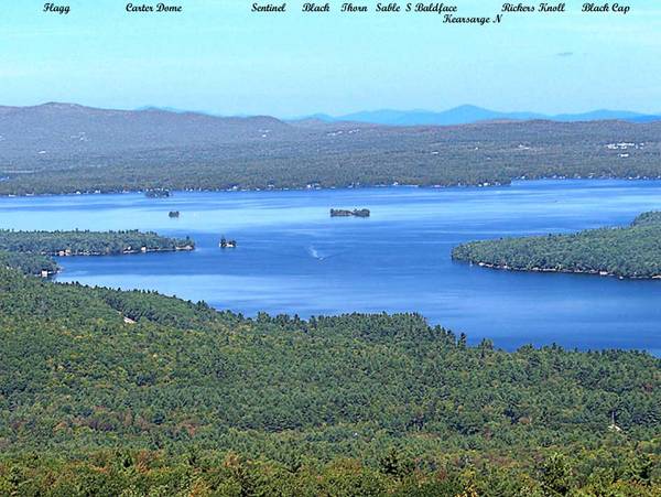 "Looking NE over the northerly portion of Alton Bay to mountains of northern NH. L to R, the 4 islands seen are Parker, Ship, Little Mark and Moose"
__________________
|
|
|
|
|
12-31-2008, 09:37 AM
|
#39 |
|
Senior Member
Join Date: Dec 2008
Location: Stoneham Ma./ Meredith
Posts: 141
Thanks: 339
Thanked 67 Times in 27 Posts
|
I agree with NHKATHY on the first picture.To me it sure does look like a shot from Parade Rd looking down to Waukewan. The second I feel more confident about. Heading south on Rt. 3 in Meredith just past the roundabout as you are heading down the hill towards Grouse Pt. that is the view. Gov. Is. dead ahead Spindle pt. on the left. Happy & healthy New Year to All.
|
|
|
|
|
12-31-2008, 03:45 PM
|
#40 | |
|
Senior Member
Join Date: Apr 2008
Location: Weirs
Posts: 56
Thanks: 17
Thanked 0 Times in 0 Posts
|
Quote:
__________________
Absolutely the best place in the world to live or play |
|
|
|
|
|
01-01-2009, 04:03 AM
|
#41 | |
|
Senior Member
Join Date: Jan 2005
Location: Florida (Sebring & Keys), Wolfeboro
Posts: 5,788
Thanks: 2,085
Thanked 742 Times in 532 Posts
|
Quote:
........ The perspective is foreshortened due to a telephoto lens, but isn't this the same spot? The roadbed and treeline are higher and the stone wall never looked so straight (and squared), but based on the large boulder in the field, the relationship of the furthest two utility poles, (one remaining tilted to starboard), not much has changed after sixty years. It's a nice perspective on the lake: I'll just have to go and get my own photo of it! Roberts Cove Road nostalgia.
__________________
Every MP who enters Winter Harbor will pass by my porch of 67 years...
|
|
|
|
|
|
01-02-2009, 06:22 AM
|
#42 | |
|
Senior Member

Join Date: Aug 2008
Location: Arlington, TX
Posts: 89
Thanks: 37
Thanked 11 Times in 6 Posts
|
Quote:
When I look closer, the views do look similar, but in the original photo, the two poles seem to be on the same side of the street, where in your photo, it looks like they are on oposite sides.
__________________
Gotta Love the Lake!! Take Care,  ILoveWinnipesaukee |
|
|
|
|
|
01-02-2009, 08:37 AM
|
#43 | |
|
Member
Join Date: Jul 2004
Posts: 49
Thanks: 38
Thanked 9 Times in 8 Posts
|
Quote:
|
|
|
|
|
|
01-02-2009, 03:30 PM
|
#44 |
|
Senior Member

Join Date: Apr 2004
Location: North Shore, MA
Posts: 1,352
Thanks: 987
Thanked 310 Times in 161 Posts
|
I am sold on this being the same place.
Nice work! R2B |
|
|
|
|
01-02-2009, 03:59 PM
|
#45 | |
|
Junior Member
Join Date: Apr 2004
Location: Swampscott, Massachusetts
Posts: 1
Thanks: 0
Thanked 0 Times in 0 Posts
|
Quote:
|
|
|
|
|
|
01-04-2009, 08:18 PM
|
#46 |
|
Senior Member
Join Date: Feb 2006
Posts: 169
Thanks: 0
Thanked 4 Times in 4 Posts
|
Mcdude> Piece o cake,Alton Mountain
|
|
|
|
|
01-06-2009, 09:56 PM
|
#47 | |
|
Senior Member
Join Date: Apr 2004
Location: Kensington, NH and Paugus Bay Marina
Posts: 656
Thanks: 323
Thanked 17 Times in 13 Posts
|
Quote:
__________________
On the boat is always waterfront! |
|
|
|
|
|
01-11-2009, 12:34 AM
|
#48 |
|
Member
Join Date: Sep 2004
Location: Port Jefferson, Long Island, NY
Posts: 42
Thanks: 0
Thanked 0 Times in 0 Posts
|
Looks like White Oaks Farm Road to me
|
|
|
|
|
| Bookmarks |
|
|


 Linear Mode

