

|
|
|
|
|
|||||||
| Home | Forums | Gallery | Webcams | Blogs | YouTube Channel | Classifieds | Calendar | Register | FAQ | Donate | Members List | Today's Posts | Search |
 |
|
|
Thread Tools | Display Modes |
 10-23-2016, 06:15 PM
|
#1 |
|
Senior Member
Join Date: Nov 2008
Location: Nj now. Spindle point in the past.(35 yrs.)
Posts: 87
Thanks: 105
Thanked 10 Times in 4 Posts
|
Does anyone remember the measured mile along side Rattlesnake Island? Used to use it to time our boats. We had no speedos in those days. Curious when it was taken down.
|

|

|
|
10-23-2016, 07:52 PM
|
#2 |
|
Senior Member
Join Date: Apr 2013
Location: Nashua/Winnisquam
Posts: 282
Thanks: 106
Thanked 96 Times in 49 Posts
|
Right fater the tird sambuca
|
|
|
|
|
10-23-2016, 08:54 PM
|
#3 |
|
Senior Member
Join Date: Mar 2006
Location: Merrimack and Welch Island
Posts: 4,046
Thanks: 1,215
Thanked 1,521 Times in 985 Posts
|
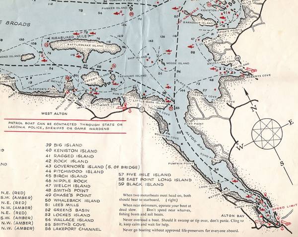
The measured mile is marked on my 1962 (blue and tan) navigation chart published by the Public Utilities Commission. Chart also showed seaplane landing strips. The Birch tree with the red paint that marked one end of the mile obviously died. Birch trees have a short lifespan compared to other species. When that side of Rattlesnake began to be developed, I suspect residents were not appreciative of boats running up and down the island doing time trials. Prior to the 60's I think nobody ever expected that side of the island would ever be developed. Too deep. Too steep. I think it was gone by the time we did water ski marathons by there in the late 60's. Sometime in the 60's was when the PUC turned over to the Marine Patrol. Perhaps the same time Goodhue Boat Yard was sold to the state as MP headquarters. The PUC had two Steelcraft boats operating out of the Weirs Channel.
More than you wanted to know. |
|
|
|
| The Following 4 Users Say Thank You to Descant For This Useful Post: | ||
|
10-24-2016, 04:59 AM
|
#4 | |
|
Senior Member
Join Date: Jan 2005
Posts: 2,084
Thanks: 1,267
Thanked 557 Times in 286 Posts
|
Quote:
|
|
|
|
|
|
10-24-2016, 06:13 AM
|
#5 | ||
|
Senior Member

Join Date: Jan 2005
Location: Florida (Sebring & Keys), Wolfeboro
Posts: 5,789
Thanks: 2,085
Thanked 742 Times in 532 Posts
|
Quote:
 Actually, there was a product sold back then. Quote:
  "Missed" by a lot!  'Don't think I ever got the same reading twice in a row! 'Don't think I ever got the same reading twice in a row!  The "Speed Wand" even bent at modest speeds. The "Speed Wand" even bent at modest speeds.As for the Measured Mile: Mid-60s, I recall motoring-by and measuring the time it took. 'Not remembering exactly, but maybe 15 minutes.  'Course, the family boat ("Yellow Jacket" with Mercury 40) was much faster. .
__________________
Every MP who enters Winter Harbor will pass by my porch of 67 years... 
|
||
|
|
|
| Sponsored Links |
|
|
|
10-24-2016, 08:30 AM
|
#6 |
|
Senior Member
Join Date: Nov 2008
Location: Nj now. Spindle point in the past.(35 yrs.)
Posts: 87
Thanks: 105
Thanked 10 Times in 4 Posts
|
Thanks, I remember two rather large signs indicating the exact start and finish. Don't remember the birch tree. You're right about development on that side of Rattlesnake back then, there was none. We had maps of the lake that showed the measured mile and the sea plane landing strips too.
|
|
|
|
|
10-24-2016, 01:12 PM
|
#7 |
|
Senior Member
Join Date: May 2004
Posts: 962
Thanks: 495
Thanked 273 Times in 174 Posts
|
I remember the alligator that dwelled on the north tip of Rattlesnake Island. 🐊
|
|
|
|
|
11-06-2016, 02:29 PM
|
#8 |
|
Senior Member

Join Date: Jul 2002
Location: Massachusetts
Posts: 332
Thanks: 0
Thanked 242 Times in 81 Posts
|
Assuming the buoys have not moved, here are three measured statute miles, +/- 20 feet:
Be sure to stay on the proper side of each buoy. |
|
|
|
|
11-06-2016, 04:58 PM
|
#9 |
|
Senior Member

Join Date: Jul 2002
Location: Rock Haven Lake - West Newfield, ME
Posts: 5,361
Thanks: 374
Thanked 1,044 Times in 490 Posts
|
This 1962 fishing map shows the measured mile along Rattlesnake
__________________
|
|
|
|
|
11-06-2016, 08:19 PM
|
#10 | |
|
Senior Member
Join Date: Nov 2013
Posts: 391
Thanks: 20
Thanked 130 Times in 93 Posts
|
Quote:
|
|
|
|
|
|
11-07-2016, 08:21 AM
|
#11 |
|
Senior Member
Join Date: Jun 2012
Location: Derry / Gilford
Posts: 1,226
Thanks: 69
Thanked 343 Times in 233 Posts
|
Who's map is that?
It also shows FL46 is nipple rock. Lots of history here!
__________________
Don't listen to me, obviously I don't understand what I'm talking about! Let's help each other save time and money: WinniGas.com |
|
|
|
|
| Bookmarks |
|
|


 Linear Mode

