

|
|
|
|
|
|||||||
| Home | Forums | Gallery | Webcams | Blogs | YouTube Channel | Classifieds | Calendar | Register | FAQ | Donate | Members List | Today's Posts | Search |
 |
|
|
Thread Tools | Display Modes |
 02-09-2012, 08:06 PM
|
#1 |
|
Senior Member

Join Date: Jul 2002
Location: Meredith
Posts: 1,670
Thanks: 1,181
Thanked 655 Times in 173 Posts
|
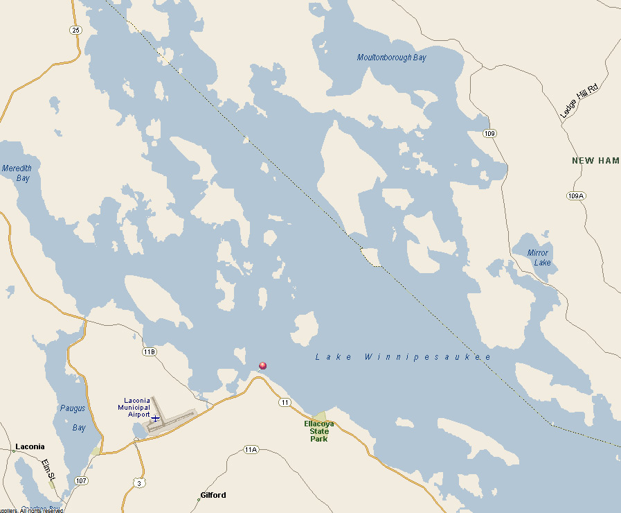
The air today was pretty hazy but I was able to get a decent photo of Mt. Washington from Lincoln Park in Gilford this morning. If you look closely you can see the ice-encrusted antenna tower at the top of the mountain.
 Click here to see a larger view.
__________________
DRH |

|

|
| The Following 27 Users Say Thank You to DRH For This Useful Post: | ||
bclaker (02-10-2012), beagle (02-10-2012), BroadHopper (02-10-2012), CateP (02-10-2012), CTYankee (02-11-2012), Diana (02-10-2012), Glidden (12-03-2012), Greene's Basin Girl (02-10-2012), GsChinadoll (02-10-2012), Happy Gourmand (02-10-2012), JasonG (02-14-2012), Jeanzb1 (02-09-2012), Lake Charm (11-24-2012), Lin (02-11-2012), Misty Blue (02-10-2012), Mooseyme (02-10-2012), Newbiesaukee (02-10-2012), NHKathy (11-25-2012), RailroadJoe (02-10-2012), Rattlesnake Gal (02-10-2012), Silver Duck (02-10-2012), Smith Point (02-10-2012), SteveA (02-10-2012), Steveo (02-10-2012), Sunbeam lodge (02-12-2012), trfour (02-10-2012), webmaster (02-10-2012) | ||
|
02-09-2012, 08:24 PM
|
#2 |
|
Senior Member
Join Date: Mar 2008
Location: Welch Island and West Alton
Posts: 3,216
Thanks: 1,172
Thanked 2,000 Times in 914 Posts
|
Nice photo. We also were there this morning and we were wondering what could be seen to the left (north) of Washington. Might that be Clay and maybe Jefferson or just two no name lumps? Not sure of the scale here. I think that Clay is about 1 mile north by north west of Washington.
|
|
|
|
|
02-09-2012, 09:16 PM
|
#3 |
|
Senior Member

Join Date: Oct 2008
Posts: 276
Thanks: 95
Thanked 65 Times in 30 Posts
|
Where is this pic taken from on the lake?
HCG |
|
|
|
|
02-09-2012, 10:16 PM
|
#4 | |
|
Senior Member
Join Date: Jul 2002
Location: Meredith
Posts: 1,670
Thanks: 1,181
Thanked 655 Times in 173 Posts
|
Quote:
__________________
DRH |
|
|
|
|
|
02-09-2012, 10:30 PM
|
#5 |
|
Senior Member
Join Date: Oct 2002
Location: Hermit Cove
Posts: 354
Thanks: 20
Thanked 68 Times in 40 Posts
|
Don...Great photo...This year we plan to make the trip up the Mountain ...this summer.
|
|
|
|
| Sponsored Links |
|
|
|
02-09-2012, 10:37 PM
|
#6 | |
|
Senior Member
Join Date: Jul 2002
Location: Meredith
Posts: 1,670
Thanks: 1,181
Thanked 655 Times in 173 Posts
|
Quote:
__________________
DRH |
|
|
|
|
|
02-09-2012, 10:55 PM
|
#7 | |
|
Senior Member
Join Date: Jul 2002
Location: Meredith
Posts: 1,670
Thanks: 1,181
Thanked 655 Times in 173 Posts
|
Quote:
__________________
DRH |
|
|
|
|
|
02-10-2012, 08:52 AM
|
#8 | |
|
Senior Member

Join Date: Jan 2011
Location: Wolfeboro
Posts: 868
Thanks: 584
Thanked 540 Times in 210 Posts
|
Quote:
This shot is beautiful. Ever thought of taking a winter trip up there in a snow coach? When I get all my video gear up here from NJ I'm going on a major quest to shoot beautiful scenes throughout the seasons. Exciting project in the works. |
|
|
|
|
|
02-10-2012, 10:12 AM
|
#9 |
|
Senior Member
Join Date: Apr 2008
Location: Moultonborough
Posts: 735
Thanks: 4
Thanked 254 Times in 166 Posts
|
Given that Mt.Washington is just to the east of north from the lake, I think the first peak to the left of Washington would be Mt. Monroe, and the slightly lower peak left of that would be Mt. Franklin. In an arc swinging out to the north of Mt.W (starting out NNW) would be Clay, Jefferson, Adams, and Madison. I doubt any of the last four are visible from the lake, as they would be hidden by the ridge between Mt.W and Mt.Monroe on the west and the Boott Spur ridge swinging down to the south from the Mt.W summit cone and around toward the east, forming the southern boundary of the Tuckerman Ravine. All this is seen here:
http://maps.google.com/maps?q=topogr...ed=0CGAQ8gEwAA |
|
|
|
|
02-10-2012, 10:13 AM
|
#10 | |
|
Senior Member

Join Date: Nov 2003
Location: Central NH
Posts: 5,252
Blog Entries: 1
Thanks: 1,447
Thanked 1,349 Times in 475 Posts
|
Quote:
 Here are a few of DCR's annotated pictures that may be be of interest:  View Northerly from Lincoln Park  Labeled View from Lockes Hill  An Annotated Version of the View from Mt Major |
|
|
|
|
| The Following User Says Thank You to Rattlesnake Gal For This Useful Post: | ||
DRH (02-10-2012) | ||
|
02-10-2012, 10:49 AM
|
#11 |
|
Senior Member
Join Date: Feb 2008
Location: Gilford, NH / Welch Island
Posts: 5,928
Thanks: 2,285
Thanked 4,939 Times in 1,915 Posts
|
Great photo DRH!!
Would that be a closeup of Welch island at the bottom?? Dan |
|
|
|
|
02-10-2012, 01:07 PM
|
#12 |
|
Senior Member
Join Date: Mar 2008
Location: Welch Island and West Alton
Posts: 3,216
Thanks: 1,172
Thanked 2,000 Times in 914 Posts
|
DickR is correct in that Washington is just east of north looking from the lake.
It looks like Clay (5,533') would line-up almost behind Monroe (5,372') with Jefferson (5,716') slightly to the left of both. Franklin (5.001) would also be slightly left but is quite a bit lower than Jefferson. Maybe Jefferson and Monroe? I don't know. Maybe if the cob railway was billowing black smoke we could tell the smoke was in front of any the lumps to the left of Martha. As soon as the cog starts-up operation, we have another photo assignment for DRH. 
|
|
|
|
|
02-10-2012, 01:13 PM
|
#13 | |
|
Senior Member
Join Date: Apr 2004
Posts: 1,072
Thanks: 336
Thanked 342 Times in 158 Posts
|
Quote:
__________________
GTO 
|
|
|
|
|
| The Following User Says Thank You to GTO For This Useful Post: | ||
BroadHopper (02-12-2012) | ||
|
02-10-2012, 04:47 PM
|
#14 |
|
Senior Member

Join Date: Jul 2004
Posts: 2,974
Thanks: 246
Thanked 736 Times in 438 Posts
|
That's a beautiful shot.
I hiked Washington in July. Weather was slightly more hazy...  I'm on the left. |
|
|
|
|
02-10-2012, 05:36 PM
|
#15 |
|
Deceased Member

Join Date: Jul 2006
Location: Gilford, NH
Posts: 2,311
Thanks: 1,070
Thanked 2,053 Times in 496 Posts
|
I stopped by Lincoln Park yesterday morning and wished I had my camera with me.!
__________________
"Before you criticize someone, walk a mile in his shoes. That way, if he gets angry he'll be a mile away and barefoot!" unknown |
|
|
|
|
02-10-2012, 05:51 PM
|
#16 |
|
Senior Member
Join Date: May 2004
Posts: 962
Thanks: 495
Thanked 273 Times in 174 Posts
|
The near island looks like the south end of Round Island. Wonderful photo!!!
|
|
|
|
| The Following User Says Thank You to Barney Bear For This Useful Post: | ||
ishoot308 (02-10-2012) | ||
|
02-10-2012, 07:31 PM
|
#17 | |
|
Senior Member
Join Date: Jul 2002
Location: Meredith
Posts: 1,670
Thanks: 1,181
Thanked 655 Times in 173 Posts
|
Quote:
 By the way, the amount of open water just north of Lincoln Park is clearly visible in this photo.
__________________
DRH |
|
|
|
|
|
02-10-2012, 08:52 PM
|
#18 |
|
Senior Member

Join Date: Jan 2005
Posts: 3,360
Thanks: 209
Thanked 764 Times in 448 Posts
|
It is Round, with Camp to the right to it. You can see the hill on Mark on the left with Timber in front.
|
|
|
|
| The Following User Says Thank You to codeman671 For This Useful Post: | ||
DRH (02-10-2012) | ||
|
02-11-2012, 10:16 PM
|
#19 |
|
Deceased Member
Join Date: Jul 2006
Location: Gilford, NH
Posts: 2,311
Thanks: 1,070
Thanked 2,053 Times in 496 Posts
|
By the way, the distance from Lincoln Park to Mt. Washington is 46.67miles.
(According to Google earth)This is a blowup part of the line that crosses right over Round. This is the entire line direct to the observatory This whole "retired thing" gives me way to much time to waste! 
__________________
"Before you criticize someone, walk a mile in his shoes. That way, if he gets angry he'll be a mile away and barefoot!" unknown |
|
|
|
| The Following 3 Users Say Thank You to SteveA For This Useful Post: | ||
|
02-12-2012, 06:33 AM
|
#20 |
|
Senior Member
Join Date: Mar 2008
Location: Welch Island and West Alton
Posts: 3,216
Thanks: 1,172
Thanked 2,000 Times in 914 Posts
|
SteveA, yes I got essentially the same distance. The bearing was about 5.4 degrees looking in the direction the photo was taken. So if you place a line of that bearing on the detail map of the Presidential Range you can see how the peaks lineup as seen from Lincoln Park.
|
|
|
|
|
02-14-2012, 03:17 PM
|
#21 |
|
Senior Member

Join Date: Apr 2004
Posts: 5,075
Thanks: 215
Thanked 903 Times in 509 Posts
|
Would go with Clay closest on left then Jefferson 2nd to the left.
__________________
SIKSUKR |
|
|
|
|
02-16-2012, 11:15 PM
|
#22 | |
|
Senior Member
|
Quote:
|
|
|
|
|
| The Following User Says Thank You to ushaggerb For This Useful Post: | ||
SteveA (02-17-2012) | ||
|
02-18-2012, 02:43 PM
|
#23 |
|
Senior Member

Join Date: Jan 2010
Posts: 228
Thanks: 29
Thanked 108 Times in 29 Posts
|
I have a bunch of photos of Mount Washington if anyone wants to peruse. I don't know what it is about that mountain and the area but I am constantly going up there and just drawn to it. They are for sale in many different varieties of printing to if you wish!
http://brendajacobsphotography.smugm...6088088_kL9M5p Last edited by Lucy Goose; 02-18-2012 at 02:44 PM. Reason: URL didn't come out right. |
|
|
|
|
11-24-2012, 02:50 PM
|
#24 |
|
Senior Member
Join Date: Jan 2010
Posts: 620
Thanks: 259
Thanked 158 Times in 100 Posts
|
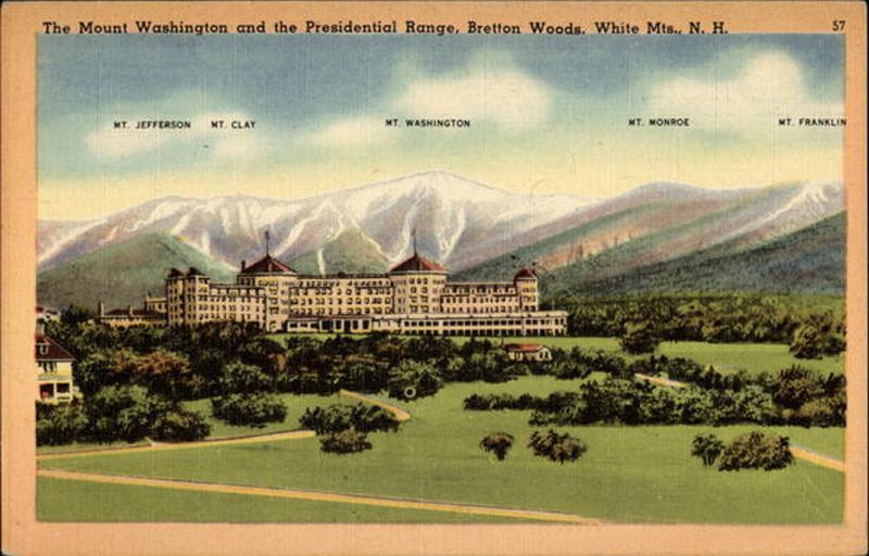
Don - Hope the picture of the painting comes through Not too bad for an old fogie
|
|
|
|
|
11-24-2012, 08:11 PM
|
#25 | |
|
Senior Member
Join Date: Jul 2002
Location: Meredith
Posts: 1,670
Thanks: 1,181
Thanked 655 Times in 173 Posts
|
Quote:
__________________
DRH |
|
|
|
|
|
11-24-2012, 09:08 PM
|
#26 | |
|
Senior Member
Join Date: Apr 2006
Location: Alton, NH
Posts: 722
Thanks: 337
Thanked 280 Times in 123 Posts
|
Quote:
__________________
Waking up in the morning is the greatest, everything after that is a bonus
|
|
|
|
|
|
| Bookmarks |
|
|


 Linear Mode

