

|
|
|
|
|
|||||||
| Home | Forums | Gallery | Webcams | Blogs | YouTube Channel | Classifieds | Register | FAQ | Members List | Donate | Search | Today's Posts | Mark Forums Read |
 |
|
|
Thread Tools | Display Modes |
|
|
 11-25-2008, 08:41 AM
|
#1 |
|
Senior Member

Join Date: Jul 2002
Location: Rock Haven Lake - West Newfield, ME
Posts: 5,343
Thanks: 370
Thanked 1,033 Times in 480 Posts
|
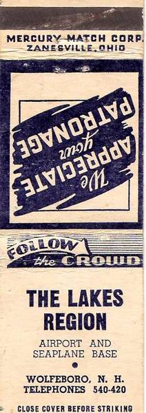
Acres Per Second: I've looked everywhere for photos to add to this interesting thread but this is all I've come up with!
__________________
|

|

|
|
12-08-2008, 06:50 AM
|
#2 |
|
Senior Member

Join Date: Jan 2005
Location: Florida (Sebring & Keys), Wolfeboro
Posts: 6,028
Thanks: 2,285
Thanked 789 Times in 564 Posts
|
Thanks for finding that.
It's interesting that the final name for the airport was "The Lakes Region Airpark", and not what's printed there. I've sent out a few feelers to determine what date that matchbook was first seen. For a possible date on that matchbook cover, you've got me studying phillumeny on the Internetthe collection of matchbook covers. What started that study was the appearance of the striking surface on the "front" of the matchbook: I recall that feature was phased out some years ago. That unsafe feature was very handy when lighting-off a backyard pile of dry brush when you would want to throw the whole lighted matchbook, but be far enough from the pile when using old gasoline as a starting fluid!  The last possible date, it turns out, was 1975 of a phase-out that began in 1965so now those phone numbers need some work. My immediate neighbor didn't recall that matchbook either, but I remember the "420" number as being the lakeside residence abutting the floatplane ramps, as pictured in the aerial photo. Where "740" rang may have been Merwin and Eleanor Horn's former Sewall Road winter residence, but might have been shared with the workshopnow razedattached to the northern end of the T-hangers pictured here earlier. (A photo of the workshop appears below). Just when the telephone numbers changed to the usual seven digits in Wolfeboro I don't recall, but based on a list of Wolfeboro emergency numbers I've saved, it may have been in the late 50s. Edited to update: That match company started in 1954, and ceased operations in 1964. Wolfeboro may have converted to convential telephone numbers as late as 1964! When I return to the lake, I can do some more sleuthingwith the list saved from that era. What was remarkable is that I apologized to my immediate neighbor about not having a telephone back then. Her reply was that, "None of us had telephones back then". (So why ruin Paradise with "modern communications", anyway).  In truth, appearing at the doorstep with the question, "Y'wannago waterskiing today?" was always a great way to start off a sunny day on Winnipesaukee.  (Though we also skied in drizzle and rain wearing ski goggles! (Though we also skied in drizzle and rain wearing ski goggles!  ) )I've learned that "Merwin" (as we knew himnot Ralph) is how his family still refers to him, and that Eleanor was an immigrant from Nova Scotia. I recall Eleanor being particularly giddy many years ago about Rt 16 being widened all the way from Rochester, which would "bring more customers to the airport".  So...I'm sending more "feelers" out on this to peg the date closer than the late 50smy best guess today.  The Airpark's heated, and quite-serious aircraft workshop, photographed in 2004:
__________________
Is it  "Common Sense" isn't. "Common Sense" isn't. ")
Last edited by ApS; 12-18-2008 at 06:44 AM. |
|
|
|
|
02-25-2009, 07:02 PM
|
#3 |
|
Senior Member
Join Date: Jul 2002
Location: Rock Haven Lake - West Newfield, ME
Posts: 5,343
Thanks: 370
Thanked 1,033 Times in 480 Posts
|
__________________
|
|
|
|
|
08-19-2009, 05:34 AM
|
#4 |
|
Senior Member
Join Date: Jan 2005
Location: Florida (Sebring & Keys), Wolfeboro
Posts: 6,028
Thanks: 2,285
Thanked 789 Times in 564 Posts
|
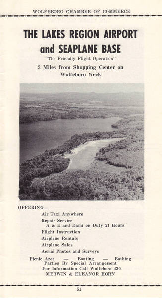
That this is from 1956 doesn't surprise me. This is the old grass landing strip, which was normal for the times and for the region. There was no telephone service—or even electricity service—ten years earlier.
The runway wasn't paved until years later. Having failed because of the freezing and heaving of underground springs, the runway was properly "plumbed" underneath and repaved the following year. Even after decades of weekly mowings, the clear-cut seen at the lower right has slowly grown back. This property lies near the end of Forest Road. Forest Road got its name because it was a dark forested tunnel to drive through to reach the end. Though I have wandered through Forest Road's many forested acres, I can't recall that the clear-cut in the photo ever existed! Not pictured there is the blue airpark hanger, added in 1979 and still in place today. The three-digit telephone number style went out by 1964. The small-appearing shoreline "notch" at the most distant part of the runway is the opening to Johnson's Cove, which lies further to the right in this still-heavily-forested photo. The airport's developer—who bought much of Johnson's Cove—had a disagreement with the town regarding a property tax increase and, among other reasons, the whole works is now in foreclosure. In 1956, Camp Wyanoke lay beyond that "notch", and reached nearly to Carry Beach. (Far right-hand corner of Winter Harbor, with Jockey Cove and Wolfeboro Bay lying beyond Carry Beach in the hazy distance). Aside from one lakefront lot, which now sports a McMansion, just one structure ( a "model home") has been built since the runway was torn up in 2006. The huge grassy clearing across the water from the former Camp Wyanoke is most likely the Melanson property off Highland Terrace in Wolfeboro. Melanson is the local realtor family who, among current (and many other offerings), sold Rattlesnake Island lots subsequent to this brochure's printing. Rattlesnake Island lies "just around the corner" from Wyanoke's Winter Harbor and—to relate it to this photo—would appear about a mile to the right of this photo.
__________________
Is it "Common Sense" isn't.
Last edited by ApS; 09-08-2009 at 05:36 AM. Reason: Add details... |
|
|
|
|
| Bookmarks |
| Thread Tools | |
| Display Modes | |
|
|


 Hybrid Mode
