

|
|
|
|
|
|||||||
| Home | Forums | Gallery | Webcams | Blogs | YouTube Channel | Classifieds | Register | FAQ | Members List | Donate | Search | Today's Posts | Mark Forums Read |
 |
|
|
Thread Tools | Display Modes |
|
|
 03-26-2020, 08:29 AM |
#1 |
|
Senior Member

|

Looking at the LAKE WINNIPESAUKEE license plate created from seven 1970's dark green & white NH plates ...... don't you think these old license plates were a better look than today's NH plate.
__________________
 .... Banned for life from local thrift store! |

|

|
|
03-26-2020, 09:22 AM
|
#2 | |
|
Senior Member

Join Date: Jan 2006
Posts: 7,041
Thanks: 803
Thanked 1,525 Times in 1,056 Posts
|
Quote:
|
|
|
|
|
|
03-26-2020, 09:47 AM
|
#3 |
|
Senior Member
Join Date: Aug 2019
Location: Parrish, Florida
Posts: 626
Thanks: 296
Thanked 225 Times in 160 Posts
|
Top-Water , I googled Meredith New Hampshire latchkey signs. There were two articles, one from the Laconia Daily Sun and the other from New Hampshire Business Weekly. In September 2018, marking Meredith 250th year, new signs were erected at all four spots. The only picture they had showed the sign on route 25 as you leave Center Harbor to enter Meredith. It did not say exactly where the other signs were.
I do not know how to send a link. But, Annie Paquette, made all the new signs and put them up. I’m not up there now, but there must be someone that can verify the location of the signs now. I hope this helps. |
|
|
|
|
03-26-2020, 09:56 AM
|
#4 |
|
Senior Member
Join Date: Aug 2019
Location: Parrish, Florida
Posts: 626
Thanks: 296
Thanked 225 Times in 160 Posts
|
It’s the sign on route 104 that is haunting me. I can see it looking like the photo that you posted, I just can’t pinpoint exactly where it is.
|
|
|
|
|
03-26-2020, 11:17 AM
|
#5 |
|
Senior Member
Join Date: Jun 2005
Location: Exeter NH
Posts: 611
Thanks: 0
Thanked 1,035 Times in 229 Posts
|
I've seen those oxen before...
I believe they are in Meredith Bay just northwest of the old shake mill that processed them into what most people call shingles. They would pull logs into the mill from that conveyor.
Now of course it's the location of Church Landing. |
|
|
|
| The Following User Says Thank You to Diver1111 For This Useful Post: | ||
Top-Water (03-26-2020) | ||
| Sponsored Links |
|
|
|
03-28-2020, 11:45 AM
|
#6 | |
|
Senior Member
Join Date: Sep 2011
Posts: 398
Thanks: 85
Thanked 109 Times in 77 Posts
|
Quote:
|
|
|
|
|
|
03-29-2020, 08:03 AM
|
#7 |
|
Senior Member
Join Date: Jan 2006
Posts: 7,041
Thanks: 803
Thanked 1,525 Times in 1,056 Posts
|
Yes, I totally agree with barefoot bay.
|
|
|
|
|
04-01-2020, 10:25 AM
|
#8 | |
|
Senior Member

Join Date: Jul 2014
Posts: 6,694
Thanks: 1,187
Thanked 2,222 Times in 1,381 Posts
|
Quote:
I stopped by the Weirs the other day to find the home on Baker Ave. my family used to rent and it's sad to see how many of those homes, and the old hotel, are rundown and not maintained. We always visit in the summer when it's busy and the focus is on fun, so I hadn't noticed how bad it was. Sent from my SM-G950U using Winnipesaukee Forum mobile app |
|
|
|
|
| The Following User Says Thank You to thinkxingu For This Useful Post: | ||
dykg (07-25-2020) | ||
|
04-02-2020, 01:23 PM
|
#9 | |
|
Senior Member

Join Date: Jul 2002
Location: Meredith
Posts: 1,699
Thanks: 1,216
Thanked 678 Times in 180 Posts
|
Quote:
__________________
DRH |
|
|
|
|
|
04-02-2020, 04:08 PM
|
#10 |
|
Senior Member
Join Date: Mar 2006
Location: Merrimack and Welch Island
Posts: 4,656
Thanks: 1,448
Thanked 1,733 Times in 1,127 Posts
|
Thank you Top-Water
Thank you Top-Water. Fun reminisces, and yes, a relief from the overwhelming number of posts and news releases on that other topic. A couple of comments. I remember the Mount Washington Sundae (2 bananas, 6 scoops of ice cream as being a creation of Weeks' Dairy Bar in Laconia and a later a second location in Meredith. As teen-agers, my friend and I used to split one. First one to the middle won, the loser had to pay. Kellerhaus came later. It was originally "Hartland" the private residence of Myron Hart. Walking into Kellerhause, you ca see where the outside pillars were that led to a porch, now closed in to make a larger interior space. Mr. Hart also owned a boathouse in the Channel and a 1948 Chris Craft 28' sedan, named "Myth". That was the second boathouse south of Thurston Marine. The first boathouse, with multi-level raised roofs was owned by Victor Tompkins who built the Queen City Motel in Manchester and owned Tobey's Motor Court in Plymouth. His boat was a 42' Chris Craft; later he moved up to a 45' CC. Both were named "Wanderer". Moving south a couple more boathouses was the homeport of the Public Utilities Comm ission boats, 2 Steelcrafts used mostly to service aids to navigation, but they had blue lights and would also perform police functions. They were succeeded by today's Marine Patrol.
Sorry to ramble. |
|
|
|
|
04-03-2020, 12:24 PM
|
#11 | |
|
Senior Member
Join Date: Mar 2006
Location: Merrimack and Welch Island
Posts: 4,656
Thanks: 1,448
Thanked 1,733 Times in 1,127 Posts
|
Quote:
|
|
|
|
|
|
04-03-2020, 12:38 PM
|
#12 | |
|
Senior Member
Join Date: Apr 2004
Posts: 505
Thanks: 12
Thanked 428 Times in 147 Posts
|
Quote:
|
|
|
|
|
|
04-03-2020, 01:16 PM
|
#13 |
|
Senior Member
Join Date: Apr 2004
Posts: 505
Thanks: 12
Thanked 428 Times in 147 Posts
|
old channel marker photo
The date on the photographs is November 12, 1965 but I cannot say whether that is the date taken or the date received. I believe these were taken to document the completion of the US Army Corps dredge of the channel and creation of the beach but cannot be certain.
|
|
|
|
| The Following 4 Users Say Thank You to Onshore For This Useful Post: | ||
|
04-03-2020, 03:03 PM
|
#14 |
|
Senior Member

Join Date: Aug 2008
Location: Beverly Cove, Ma
Posts: 359
Thanks: 287
Thanked 148 Times in 82 Posts
|
Low!
Yes, some great old photos. I'm just curious. The last photo looks like the tide's out!. Was the dam control different in those days or was it a bad drought?
__________________
I'd rather be relax'n at Winnipesaukee |
|
|
|
|
04-03-2020, 04:57 PM
|
#15 |
|
Senior Member
Join Date: Aug 2008
Location: Beverly Cove, Ma
Posts: 359
Thanks: 287
Thanked 148 Times in 82 Posts
|
Shore Things had mentioned the Army Corps dredging work back in the '60s.
I wonder if they lowered the level for that? We're never at the lake beyond the end of October. I never knew it was lowered that much.
__________________
I'd rather be relax'n at Winnipesaukee |
|
|
|
|
04-03-2020, 05:17 PM
|
#16 |
|
Senior Member
Join Date: Aug 2019
Location: Parrish, Florida
Posts: 626
Thanks: 296
Thanked 225 Times in 160 Posts
|
I remember that year. I was 15 years old. It was the second year that we lived in our new home. We had a beautiful natural sand beach in front of the house. Unfortunately, there were many large rocks and boulders just below the water’s surface. It wasn’t exactly a perfect beach, but there wasn’t anything we could do about it.
It was two years later that the lake went down so low. My parents had no idea why this was happening. My father always had all kinds of radio equipment and always knew everything that was going on, or so I thought. So, my parents decided what a wonderful opportunity to have all the rocks removed from the beach. The company came in with their big equipment and the bulldozers could go approximately 30 feet out before there was any water. They worked all day long digging up the big rocks and pushing them over to the sides of the beach. We talked about that year for a long time after that, always wondering if the lake would ever go that low again and never understanding why it did that year. So, after all these years, it was because they put in Weirs Beach? That is so cool. |
|
|
|
|
04-05-2020, 12:18 PM
|
#17 | |
|
Senior Member
Join Date: Mar 2006
Location: Merrimack and Welch Island
Posts: 4,656
Thanks: 1,448
Thanked 1,733 Times in 1,127 Posts
|
Shore Things Photos
Quote:
In the 50's the name was changed from Weirs to Weirs Beach. The second photo shows the expanded "new" docks at the south end of the old city docks. Those were built in the mid 60's. In the fifties there were still three stick multi-pilings lining Weirs Channel from when the old Mount was moored there in the winter. The picture shows mostly single piles set just for navigation. I was away at school 1965-66, so I have no personal recollection of the low water shown. I guess the water level was much closer to normal by the next summer as low water does not stand out in my mind. |
|
|
|
|
| The Following User Says Thank You to Descant For This Useful Post: | ||
Top-Water (04-05-2020) | ||
|
04-06-2020, 11:50 AM
|
#18 |
|
Senior Member
Join Date: Mar 2006
Location: Merrimack and Welch Island
Posts: 4,656
Thanks: 1,448
Thanked 1,733 Times in 1,127 Posts
|
Exciting
Thanks Top-Water. I was a pre-schooer in those days, but I remember the races somewhat. We had a 1950 30' Chris Craft cabin cruiser, and my father often volunteered to be a picket boat for these races. 40 years later, we served as "Turn #3" for the offshore power boat races held in the Broads.
|
|
|
|
|
04-10-2020, 08:11 AM
|
#19 |
|
Senior Member
Join Date: Jan 2006
Posts: 7,041
Thanks: 803
Thanked 1,525 Times in 1,056 Posts
|
I could be wrong but I think he stayed in Wolfeboro. I know a lot of the Red Sox stayed on Sewall Road.
|
|
|
|
| The Following User Says Thank You to tis For This Useful Post: | ||
Top-Water (04-10-2020) | ||
|
04-12-2020, 02:24 PM
|
#20 | |
|
Senior Member

Join Date: Apr 2004
Posts: 614
Thanks: 307
Thanked 436 Times in 146 Posts
|
Rose-Edward Lodge and Cabins
Quote:
http://weirsbeach.com/services/chamb...irs-beach-map/ look at location 26 north of The Weirs which is entitled: Rose-Edward Lodge and Cabins
__________________
Lake Winni - The only place I want to be during the summer. 
|
|
|
|
|
| The Following User Says Thank You to Senter Cove Guy For This Useful Post: | ||
Top-Water (04-12-2020) | ||
|
04-13-2020, 09:34 AM
|
#21 | |
|
Senior Member

Join Date: Aug 2004
Location: Moultonborough & CT
Posts: 2,550
Thanks: 1,072
Thanked 672 Times in 369 Posts
|
Quote:
Sent from my iPad using Winnipesaukee Forum mobile app |
|
|
|
|
| The Following User Says Thank You to Pineedles For This Useful Post: | ||
Top-Water (04-13-2020) | ||
|
04-19-2020, 08:41 AM
|
#22 | |
|
Senior Member

Join Date: Jul 2002
Location: Rock Haven Lake - West Newfield, ME
Posts: 5,344
Thanks: 370
Thanked 1,033 Times in 480 Posts
|
Quote:
That's Kimball's Castle. It was built by Benjamin Kimball who was a rich railroad magnate and helped to build the Lakeshore Railroad. Do a search on Photopost to find more images 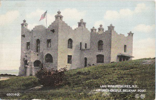
__________________
|
|
|
|
|
|
07-28-2020, 10:54 AM
|
#23 | |
|
Junior Member
Join Date: Feb 2015
Posts: 7
Thanks: 0
Thanked 4 Times in 3 Posts
|
Quote:
|
|
|
|
|
| The Following User Says Thank You to sarc For This Useful Post: | ||
JacksonB (08-17-2020) | ||
|
08-14-2020, 04:32 PM
|
#24 | |
|
Senior Member

Join Date: Jan 2005
Location: Florida (Sebring & Keys), Wolfeboro
Posts: 6,069
Thanks: 2,318
Thanked 798 Times in 571 Posts
|
 Today is VJ-Day, 75 Years... Quote:
He said he was on board a ship when World War II ended in the South Pacific. There was no real celebration of "VJ-Day" aboard, as alcohol wasn't permitted on U.S. ships. (Although their torpedoes could be tapped for 190-grain "fuel").
|
|
|
|
|
|
| Bookmarks |
| Thread Tools | |
| Display Modes | |
|
|


 Hybrid Mode

