

|
|
|
|
|
|||||||
| Home | Forums | Gallery | Webcams | Blogs | YouTube Channel | Classifieds | Register | FAQ | Members List | Donate | Search | Today's Posts | Mark Forums Read |
 |
|
|
Thread Tools | Display Modes |
|
|
 04-11-2011, 02:41 PM |
#1 |
|
Senior Member

Join Date: Mar 2003
Location: Merrymeeting Lake, New Durham
Posts: 2,229
Thanks: 305
Thanked 800 Times in 369 Posts
|

The difference in the past 24 hours is dramatic. Looking at the webcams, dark areas and open water showing up everywhere, and in places that didn't even show a hint 2 days ago. Large "steam" plumes showing on Wolfeboro and other cams.
Seems someone hit the fast forward button! (though won't help me...my April 8th guess is already done) 
|

|

|
|
04-11-2011, 02:55 PM
|
#2 |
|
Senior Member

Join Date: Apr 2004
Location: Kuna ID
Posts: 2,755
Thanks: 244
Thanked 1,942 Times in 802 Posts
|
Tough to get terribly excited about the upcoming season when you look at the gas prices. Ugh! It's going to hurt this year no doubt about it. Little more sittin' at anchor and a little less cruising around. I may have to cut back a little bit on my salmon fishing too.
|
|
|
|
|
04-11-2011, 03:31 PM
|
#3 |
|
Senior Member
Join Date: Jul 2009
Location: On the move...
Posts: 987
Thanks: 113
Thanked 248 Times in 133 Posts
|
Maxum, no doubt that it will impact the boating community. This is where trailer boaters have the advantage as at least they can fill up at the road stations.
I can't even imagine paying for gas for the larger cruisers out on the water. Unfortunately the US is quickly becoming less of a financial force as the Chinese economic consumption approaches ours. This is simply the beginning as the next couple decades we're going to see major changes in economies across the globe. Even little places like the Lakes Region are impacted by global events. With the supply/demand equation so out of whack, I don't know what to predict with fuel prices anymore. This year's fuel price run-up was predicted last Fall by many economics and energy traders. I don't understand the energy markets but when you can predict these things it always makes me suspicious of how speculators are driving the price. Our supplies seem to reflect gas is over-priced but they're now saying gas is headed for over $4 "easily". |
|
|
|
|
04-11-2011, 04:12 PM
|
#4 | |
|
Junior Member
Join Date: Apr 2011
Posts: 10
Thanks: 4
Thanked 1 Time in 1 Post
|
Quote:
Despite the unrest in the middle east and Africa, Saudi Arabia and other OPEC nations upped production to make up for any lost in the troubled areas. Lybia's oil didn't even come to the US. Traders are just using this as their excuse to force prices higher. Can't even blame Exxon/Mobil or BP for the rise. That said, the 12' aluminum V-hull I bought my wife for her birthday last year only used about 8-9 gallons all summer, and we fished a ton! 
|
|
|
|
|
|
04-11-2011, 08:34 PM
|
#5 | |
|
Senior Member

Join Date: Sep 2004
Posts: 1,254
Thanks: 423
Thanked 366 Times in 175 Posts
|
Quote:
As a private citizen you are equally free to sell a future to "drive the price down". Then buy it when the price is lower. Every dollar made by one is lost by another. |
|
|
|
|
| The Following User Says Thank You to Rattlesnake Guy For This Useful Post: | ||
LadyoftheLake (04-13-2011) | ||
| Sponsored Links |
|
|
|
04-12-2011, 07:42 AM
|
#6 |
|
Member
Join Date: Jul 2010
Posts: 39
Thanks: 18
Thanked 53 Times in 15 Posts
|
Ice is looking gray in spots
From my vantage point in Alton looking over the lake it got very gray in spots overnight, especially between Rattlesnake and Alton Bay. With this wind there might be some open water today. Up towards Meredith and Center Harbor it still looks white. I will try to get a picture tomorrow and post it but no time today.
|
|
|
|
|
04-12-2011, 10:57 AM
|
#7 |
|
Senior Member

Join Date: Jul 2002
Location: Alton Bay,NH, and FL
Posts: 2,359
Thanks: 19
Thanked 577 Times in 183 Posts
|
Lake Temp up again
The temperature of the lake reported by the dam operators is up to 38 degrees. Last year we had ice out at 39 degrees. (though it was 39 degrees for many days before the ice went out.)
Lily Pond was mostly iced is except for a bit at the edges on Saturday. If anyone goes by could let us know if the ice is out. IG
__________________
Island Girl ....... Make Lemonade |
|
|
|
|
04-12-2011, 12:39 PM
|
#8 |
|
Senior Member

Join Date: Jul 2002
Location: Meredith
Posts: 1,699
Thanks: 1,216
Thanked 678 Times in 180 Posts
|
Big Change
Yesterday's rain, fog and mild temps really affected the ice. I took this picture from the Scenic View on Rt. 11 in Alton around noon today, looking toward Wolfeboro:

__________________
DRH |
|
|
|
| The Following 9 Users Say Thank You to DRH For This Useful Post: | ||
Grady223 (04-13-2011), Just Sold (04-12-2011), Pepper (04-12-2011), Rattlesnake Gal (04-13-2011), Resident 2B (04-12-2011), Steveo (04-12-2011), Sunset Bob (04-12-2011), trfour (04-12-2011), Webbsatwinni (04-12-2011) | ||
|
04-12-2011, 01:33 PM
|
#9 |
|
Senior Member
Join Date: Mar 2003
Location: Merrymeeting Lake, New Durham
Posts: 2,229
Thanks: 305
Thanked 800 Times in 369 Posts
|
I checked the 2' water temperature on the WeatherCenter Cam page early this morning. It was still just under 37 degrees.
Right now it's reading 39.7! I'm not sure if it actually rose that fast, or if it just hadn't been updating for awhile. In any case, if the reading is true, it's at the seemingly magic 40 degrees when ice-out happens quickly. The Water Temp page on this site shows the Lakeport Dam at 38 as of today. On Sunday when I was there, there was almost no open water on the shoreline of Merrymeeting. Now you can see it is at least 20' out. http://65.175.138.198/view/view.shtml |
|
|
|
|
04-12-2011, 02:01 PM
|
#10 |
|
Senior Member

Join Date: Jan 2005
Posts: 3,638
Thanks: 225
Thanked 863 Times in 525 Posts
|
I just got back from an airboat ride to Mark from Cattle Landing. It is open all the way across to Bear (small strip approaching Bear). There is 5" of wet, broken ice between Cattle and Mark. The airboat was having a tough time getting on top of it without breaking through. Coming across from Glendale the ice is strong enough to hold the boat I am told. I took a few cell phone pictures that I will upload later tonight.
Gilford Yacht Club is ice-free to the end of the outer dock and Smith Cove is going quickly. In Alton the ice is past the pavilion. Everywhere you look it is very porous and dark with lots of cracks. |
|
|
|
| The Following 4 Users Say Thank You to codeman671 For This Useful Post: | ||
|
04-12-2011, 06:47 PM
|
#11 |
|
Senior Member
Join Date: Jun 2007
Posts: 2,129
Thanks: 380
Thanked 1,016 Times in 345 Posts
|
The docks are free at 19 mile bay. It is open about 50 yards out. 20 Mile Bay is just starting to get some open water near RT109. Ice is looking very Gray now......
|
|
|
|
| The Following User Says Thank You to Lakesrider For This Useful Post: | ||
Grant (04-13-2011) | ||
|
04-13-2011, 09:04 AM
|
#12 |
|
Senior Member
Join Date: Jul 2002
Location: Concord NH
Posts: 681
Thanks: 97
Thanked 48 Times in 39 Posts
|
Ice Out
the docks at WAM are mostly Ice free now and the channel looks wide open. there Is some Ice floating around the middle of the docks. I would think It will be totally Ice free by the end of the week.
__________________
 dont worry be happy 
|
|
|
|
| The Following User Says Thank You to fpartri497 For This Useful Post: | ||
winniforlife (04-13-2011) | ||
|
04-13-2011, 09:26 AM
|
#13 |
|
Senior Member
Join Date: Mar 2008
Location: Welch Island and The Taylor Community
Posts: 3,406
Thanks: 1,271
Thanked 2,157 Times in 989 Posts
|
From the Ames Farm area the ice is very dark and broken into many medium size sheets. A good wind would start to break this up.
Looking from Belknap Point today toward Welch and Round the gaps are fewer and the ice is not as dark, this will take a little longer. |
|
|
|
|
04-13-2011, 10:33 AM
|
#14 |
|
Senior Member
Join Date: Apr 2004
Posts: 530
Thanks: 47
Thanked 123 Times in 63 Posts
|
Photos!!!!
Photos, we want PHOTOS!!!!
Please |
|
|
|
| The Following User Says Thank You to Steveo For This Useful Post: | ||
Webbsatwinni (04-14-2011) | ||
|
04-13-2011, 10:37 AM
|
#15 | |
|
Senior Member

Join Date: Jul 2002
Location: Pennsyltuckey, Tuftonboro, Moultonborough
Posts: 1,511
Thanks: 390
Thanked 234 Times in 128 Posts
|
Quote:
Don't say I never gave you anything. 
__________________
"When I die, please don't let my wife sell my dive gear for what I told her I paid for it." |
|
|
|
|
|
04-13-2011, 01:49 PM
|
#16 |
|
Senior Member

Join Date: Nov 2003
Location: Central NH
Posts: 5,253
Blog Entries: 1
Thanks: 1,455
Thanked 1,357 Times in 476 Posts
|
 Pictures from Mid-Day Today
For those of you checking into the Forum after dark, here are the webcam pictures from mid day today, April, 13th.
Silver Lake in Hollis had ice-out either Sunday or Monday and is usually one week ahead of Lake Winnipesaukee.  Alton Bay Cam  BearCam2  Black Cat Island Cam  Downing's Landing  2011 Echo Shores Ice-Out Watch, by DRH  FairhavenCam  Governors Island Cam  Moultonborough Bay Cam  Overlook Cam on Paugus Bay  Pine Island South Cam  Rattlesnake IslandCam 2011 Ice-Out, by Island Girl  Photo for April 13th has not been posted yet. Silver Sands Ice-Out Picture of the day  SmithCoveCam  Varney Point Cam, Gilford  WeirsCam  WinnipesaukeeCam 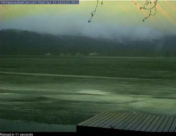 WinnipesaukeeCam 2  WolfeboroCam Other Area Lakes:  Lake Wentworth Cam  Merrymeeting Lake Webcam  Winnisquam Marine Webcam   Ossipee Lake Webcams The ice is really taking a beating with this rain!
|
|
|
|
| The Following 5 Users Say Thank You to Rattlesnake Gal For This Useful Post: | ||
AB_Monterey (04-14-2011), Merrymeeting (04-13-2011), Nauti Crew (04-14-2011), Rattlesnake Guy (04-13-2011), Sunset Bob (04-13-2011) | ||
|
04-13-2011, 02:08 PM
|
#17 |
|
Senior Member
Join Date: Jan 2005
Posts: 3,638
Thanks: 225
Thanked 863 Times in 525 Posts
|
Pictures as promised. Starting left to right, leaving Mark to head towards Cattle Landing, looking off my dock towards Mink, looking off my deck across to Camp Lawrence, and looking left off my dock towards Bear, to the left of Lawrence.
|
|
|
|
| The Following 8 Users Say Thank You to codeman671 For This Useful Post: | ||
Bear Island South (04-13-2011), Bear247 (04-14-2011), Diana (04-14-2011), Mink Islander (04-14-2011), Nauti Crew (04-14-2011), Rattlesnake Gal (04-13-2011), Sunset Bob (04-14-2011), Webbsatwinni (04-14-2011) | ||
|
04-11-2011, 04:51 PM
|
#18 | |
|
Senior Member

Join Date: Apr 2004
Location: Eastern MA & Frye Island/Sebago Lake, Maine
Posts: 959
Thanks: 258
Thanked 351 Times in 158 Posts
|
Quote:
Over in my neck of the woods, parts of the lake that had ice fishermen on them on Saturday reporting 14 inches of ice with 8 of it being solid black ice are now grayish/black and moving in the wind. It will easily be open water by the end of the week if not sooner. BT
__________________
" Live for today because yesterday is gone and tomorrow may never come" |
|
|
|
|
|
04-14-2011, 09:03 PM
|
#19 | |
|
Senior Member
Join Date: Apr 2004
Location: Eastern MA & Frye Island/Sebago Lake, Maine
Posts: 959
Thanks: 258
Thanked 351 Times in 158 Posts
|
Quote:
__________________
" Live for today because yesterday is gone and tomorrow may never come" |
|
|
|
|
|
04-14-2011, 11:50 PM
|
#20 |
|
Senior Member

Join Date: Jan 2007
Location: Center Harbor
Posts: 1,049
Thanks: 15
Thanked 472 Times in 107 Posts
|
Preliminary Iceout Prediction
Conditions are beginning to look favorable for iceout in the Sunday to Tuesday time frame. The ice is now breaking up daily and is about 2 inches thick. It is composed of the late season "candle" crystals that are weakly joined. Within a few hundred feet of its edges, the ice is rolling in the waves rather than holding flat.
A strong late winter blizzard on the great plains is pushing a cold front into the Mississippi River states tonight, a process that is generating severe thunderstorms along the cold front and a change to cold weather behind it. This storm system will track to our west this weekend, initially causing our local wind to increase from the southeast -- a major wave-generating direction for the open lake. The cold front now pushing severe weather through the nation's mid-section will overtake this area on Sunday. It will bring rain, possible thunderstorms, and strong wind gusts to the lake, along with a wind shift into the northwest -- the other major wave-generating direction here. Along with the cold front there will be rain and possible thunderstorms. The combination of weather conditions will significantly reduce the amount of ice in the lake -- perhaps bringing official iceout. The only factor that will not be present are warm temperatures, or this prediction would express greater confidence. Temperatures may dip into the 20s for the next two nights, and we may see a few more snowflakes this weekend also. Despite lack of warm temps this year, the ice has weakened thanks to recent rain and dense fog. The weaker ice will clear out very quickly if we get strong enough wind. It is beginning to look like a windy weekend, with wind coming from the lake's two biggest wave-generating directions. If the wind is able to clear the main lake of ice, some patches may remain in the protected bays. Warmer weather -- near 60 F -- is in the forecast for after Monday. That may be enough to melt any remaining ice. Official iceout is declared by Emerson Aviation of Laconia Airport, when the M/S Mount Washington can reach all of her ports without hitting any ice. I am forecasting a 75% chance of iceout during or within 48 hours after after this weekend's expected stormy weather, and a 90% chance of iceout within the next 7 days. |
|
|
|
| The Following 13 Users Say Thank You to CanisLupusArctos For This Useful Post: | ||
AB_Monterey (04-15-2011), Bear247 (04-15-2011), CTYankee (04-15-2011), DRH (04-15-2011), Grady223 (04-15-2011), hancoveguy (04-15-2011), Just Sold (04-15-2011), Pepper (04-15-2011), secondcurve (04-15-2011), Sully (04-15-2011), trfour (04-15-2011), Webbsatwinni (04-15-2011), Whimsey (04-17-2011) | ||
|
04-15-2011, 06:59 AM
|
#21 |
|
Senior Member

Join Date: Apr 2008
Location: Southboro, MA
Posts: 579
Thanks: 75
Thanked 384 Times in 170 Posts
|
Tuesday sounds good to me that is my Ice-out guess
|
|
|
|
|
04-15-2011, 12:26 PM
|
#22 |
|
Senior Member
Join Date: Mar 2008
Location: Welch Island and The Taylor Community
Posts: 3,406
Thanks: 1,271
Thanked 2,157 Times in 989 Posts
|
Going fast
View today from Belknap Point, Welch Island on the right.
|
|
|
|
| The Following 5 Users Say Thank You to Slickcraft For This Useful Post: | ||
Diana (04-15-2011), ishoot308 (04-16-2011), Just Sold (04-15-2011), Pepper (04-15-2011), Rattlesnake Gal (04-15-2011) | ||
|
04-15-2011, 01:37 PM
|
#23 |
|
Senior Member

Join Date: Apr 2004
Location: Suncook, NH, but at The Lake at Heart
Posts: 2,616
Thanks: 1,086
Thanked 434 Times in 210 Posts
|
Modis shows Alton Bay and the area towards Lee's Mill are open plus a big area of the lower middle part of the lake but not much else yet.
http://ge.ssec.wisc.edu/modis-today/...esolution=250m
__________________
Just Sold  At the lake the stress of daily life just melts away. Pro Re Nata |
|
|
|
|
04-15-2011, 01:45 PM
|
#24 |
|
Senior Member

Join Date: Mar 2010
Location: Laconia
Posts: 595
Thanks: 557
Thanked 1,569 Times in 274 Posts
|
View from today, taken from Lincoln Park in Gilford. Straight ahead is Round island with a snow-capped Mount Washington off in the distance. Ice out should be soon.

__________________
"The true meaning of life is to plant trees, under whose shade you do not expect to sit." Nelson Henderson (1865-1943) |
|
|
|
| The Following 3 Users Say Thank You to Airedale1 For This Useful Post: | ||
|
04-15-2011, 04:15 PM
|
#25 | |
|
Senior Member
Join Date: Nov 2003
Location: Central NH
Posts: 5,253
Blog Entries: 1
Thanks: 1,455
Thanked 1,357 Times in 476 Posts
|
MODIS Today
Quote:
 You're right! Happily, today's picture has much less clouds for a clearer view of the lake. |
|
|
|
|
|
04-15-2011, 06:18 PM
|
#26 |
|
Senior Member
Join Date: Jul 2002
Location: Concord NH
Posts: 681
Thanks: 97
Thanked 48 Times in 39 Posts
|
Lake water level
I am quite suprised at how low the water level Is Inside the marina. Usually at this time of year It is very high

__________________
dont worry be happy
|
|
|
|
|
04-16-2011, 01:59 AM
|
#27 | |
|
Senior Member

Join Date: Nov 2002
Location: The Lakes, Central NH. and Dallas/Fort Worth TX.
Posts: 3,694
Blog Entries: 3
Thanks: 3,067
Thanked 472 Times in 236 Posts
|
Excellence From The Dam...
Quote:
 Terry ______________________________________
__________________
trfour Always Remember, The Best Safety Device In The Boat, or on a PWC Snowmobile etc., Is YOU! Safe sledding tips and much more; http://www.snowmobile.org/snowmobiling-safety.html |
|
|
|
|
|
04-16-2011, 07:30 AM
|
#28 |
|
Senior Member
Join Date: Apr 2008
Location: Southboro, MA
Posts: 579
Thanks: 75
Thanked 384 Times in 170 Posts
|
This picture was taken yesterday by a friend, standing at cattle landing looking south towards Bear.
|
|
|
|
|
04-16-2011, 06:30 PM
|
#29 | |
|
Senior Member
Join Date: Aug 2010
Location: Natick Ma.
Posts: 110
Thanks: 149
Thanked 20 Times in 15 Posts
|
Quote:
|
|
|
|
|
|
04-17-2011, 07:09 AM
|
#30 |
|
Junior Member
Join Date: Mar 2009
Location: East Bear Island
Posts: 6
Thanks: 13
Thanked 5 Times in 1 Post
|
East Bear Island Access
Hi All,
We've been watching the web cams and all of your comments excitedly from home. Who'd have thought watching ice melt could be so much fun! We were going to head out to East Bear Island on Monday, 4/18 from Smith Cove. Has anyone been out there among the ice flows to know if it's clear enough? Have a great day! EN |
|
|
|
|
04-17-2011, 07:15 AM
|
#31 |
|
Senior Member
Join Date: Nov 2003
Location: Central NH
Posts: 5,253
Blog Entries: 1
Thanks: 1,455
Thanked 1,357 Times in 476 Posts
|
 Snake Eyes  The lake is open this morning on the Broads side of the island! It's supposed to get windy later, which means ice-out could happen today. |
|
|
|
| The Following 3 Users Say Thank You to Rattlesnake Gal For This Useful Post: | ||
|
04-16-2011, 07:45 AM
|
#32 | |
|
Senior Member
Join Date: Apr 2008
Location: Southboro, MA
Posts: 579
Thanks: 75
Thanked 384 Times in 170 Posts
|
Quote:
right where it should be for this time of year, perfect height for getting the dock in next week
|
|
|
|
|
|
04-16-2011, 08:00 AM
|
#33 |
|
Senior Member
Join Date: Apr 2009
Location: Rattlesnake Island
Posts: 140
Thanks: 58
Thanked 46 Times in 24 Posts
|
Rattlesnake tomorrow??
So what are my chances of getting out of Minge Cove and over to the "quiet" side of Rattlesnake tomorrow?? I can't stand it any longer??

|
|
|
|
|
04-16-2011, 08:20 AM
|
#34 |
|
Member
Join Date: Jul 2010
Posts: 39
Thanks: 18
Thanked 53 Times in 15 Posts
|
Minge Cove to Rattlesnake
Doubtful, very doubtful. Looks pretty solid from our house overlooking Rattlesnake this morning. If it looks better towards the end of the day I will let you know.
|
|
|
|
|
04-16-2011, 04:58 PM
|
#35 |
|
Senior Member

Join Date: Mar 2009
Location: Hampton & Rattlesnake Island
Posts: 178
Thanks: 33
Thanked 70 Times in 32 Posts
|
Rattlesnake Isl.
I have a friend that boated out to the quiet side of Rattlesnake yesterday afternoonm ames Farm. Some ice left below Aligator Point, but all else clear. haven't heard if he got around to other side. He sent a picture, but i haven't posted it yet.
|
|
|
|
|
| Bookmarks |
| Thread Tools | |
| Display Modes | |
|
|


 Hybrid Mode

